Key facts
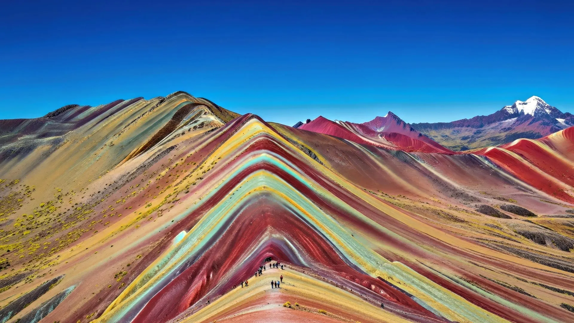
- Rainbow Mountain, or Vinicunca (Montaña de 7 Colores), is a peak with mineral stripes in the Vilcanota range, facing snowcapped Ausangate.
- It’s in Pitumarca District (Canchis), on the border with Cusipata (Quispicanchi), about 3 hours by road southeast of Cusco.
- The viewpoint sits at about 5,036 m; some sources, such as Andina, put the summit at about 5,200 m. The trail starts above 4,600 m.
- You visit it on a full-day trip: you leave Cusco between 4:00 and 4:30 a.m. and hike up for 1 h 30 min to 2 h, with optional horses for part of the way.
- The entrance fee is a community fee, paid in cash and not covered by the Cusco Tourist Ticket; confirm the day before that access is open.
- Go from April to November, and only once you’ve spent at least two or three days acclimatizing in Cusco.
Rainbow Mountain, also known as Vinicunca, the Mountain of Seven Colors or Montaña de 7 Colores, is a peak striped in red, ocher, green and lilac in the Vilcanota mountain range, southeast of Cusco. You visit it on a full-day trip: about 3 hours by road and a 1 h 30 min to 2 h hike up to a viewpoint at about 5,036 m. The hike is short but very high, so it only makes sense once you’ve acclimatized in Cusco.
Rainbow Mountain at a glance
| Fact | Rainbow Mountain (Vinicunca) |
|---|---|
| Other names | Mountain of Seven Colors, Montaña de 7 Colores, Montaña de Colores, Montaña Arcoíris, Winikunka |
| Location | Pitumarca District, Canchis Province, Cusco Region, on the border with Cusipata (Quispicanchi) |
| Mountain range | Vilcanota, near snowcapped Ausangate |
| Viewpoint elevation | About 5,036 m; some sources give about 5,200 m for the highest point |
| Distance from Cusco | About 3 hours by road |
| Hike | 1 h 30 min to 2 h up and a little less down |
| Difficulty | Demanding because of the altitude, not the distance |
| Entrance fee | Community fee, paid in cash; not covered by the Cusco Tourist Ticket |
| Best season | April to November; driest from May to October |
| Trip length | A full day, about 14 hours from your hotel |
Where is Rainbow Mountain?
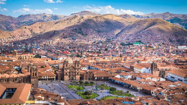
Vinicunca is in the Andes of southern Peru, in the Cusco Region, about 80 km southeast of the city as the crow flies. It belongs to Pitumarca District, in Canchis Province, and sits on the border with Cusipata District, in Quispicanchi Province. That position on the boundary explains why there are two access routes, one through each district, and also the disputes you’ll read about below.
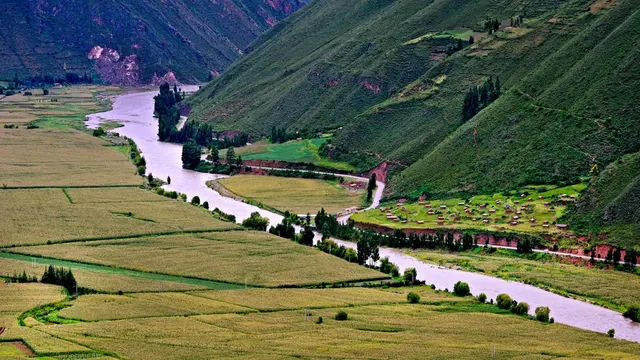
It’s part of the Vilcanota range, the same one as snowcapped Ausangate, which at about 6,384 m is the highest mountain in the region. On a clear day, from the Vinicunca viewpoint you can see ice-covered Ausangate on the other side of the valley. This is high puna country: grasslands, high-altitude wetlands known as bofedales, herds of alpacas and llamas, and small Quechua communities that live from herding and, for some years now, from tourism too.
To get there you take the highway from Cusco toward Sicuani and Puno. You pass through the South Valley, with towns like Andahuaylillas, and through Quiquijana and Checacupe, before turning off toward the communities at the trailhead. It’s the same road that leads to the temple of Raqchi and to the area’s other rainbow mountain, Palcoyo.
Rainbow Mountain elevation
Rainbow Mountain’s elevation is about 5,036 m at the viewpoint visitors reach. That’s the figure we use throughout this site. You’ll also see another number repeated often, about 5,200 m: Peru’s state news agency, Andina, puts the summit of Vinicunca at that height. The difference comes from the fact that the end of the trail isn’t the same as the top of the mountain, and GPS readings and maps don’t always agree. Either way, you’re above 5,000 m, higher than any point on the classic treks to Machu Picchu.
The trail itself starts above 4,600 m. That means all the effort happens with far less oxygen than in Cusco, which sits at about 3,399 m. That’s where the real difficulty lies: the climb isn’t long, but every step takes work.
| Place | Approximate elevation |
|---|---|
| Cusco (city) | 3,399 m |
| Vinicunca trailhead | Over 4,600 m |
| Humantay Lake | 4,200 m |
| Palcoyo | About 4,900 m |
| Rainbow Mountain viewpoint | About 5,036 m |
| Vinicunca summit, according to Andina | About 5,200 m |
| Snowcapped Ausangate | About 6,384 m |
Important: don’t do Rainbow Mountain during your first two days in Cusco. Save it for the end of your trip, when you have no symptoms of soroche (altitude sickness) and haven’t had alcohol the night before. If you have a heart or respiratory condition, are pregnant or are traveling with young children, check with your doctor first. Everything you need to know is in our guide to altitude sickness in Cusco.
Why is the mountain so colorful?
The colors aren’t paint or a photo trick, although many images on social media are heavily saturated. According to the Geological Society of Peru, as cited by Andina, the stripes are marine, lake and river sediments that were laid down in layers. Tectonic movements lifted and tilted them, and the oxidation of minerals with moisture, together with erosion, exposed each layer with its own shade.
This is how that explanation matches colors to minerals:
- Red: argillites and clays.
- Fuchsia and pink: red clay, mud and sand.
- Purple or lilac: clay, calcium carbonate and silicates.
- Green: iron, magnesium and copper oxides.
- Mustard or gold: limonites and calcareous sandstones with sulfide minerals or sulfur.
- White and cream: quartz sandstones or sand and limestones.
Does it really have seven colors?
The name is more popular than accurate. Depending on the light, the humidity and the snow, you’ll make out between four and seven clearly defined shades. The colors look more intense under an overcast sky or right after a light rain; in strong midday sun, the tones flatten out. And in the rainy season, a layer of snow can cover everything. Go with realistic expectations: the landscape is striking, but it doesn’t look like the edited photos.
History: from alpaca pasture to Peruvian icon
For centuries, Vinicunca was just another hill in the puna, known only to local herders. According to Andina, it opened to tourism in 2016 and its fame grew very quickly thanks to photos on social media. The same agency links today’s visible colors to the retreat of the snow that used to cover these mountains, which it attributes to climate change in the Andes. Within a few years it was receiving thousands of visitors: Andina reports up to 2,000 people a day at peak times.
That success brought problems. In 2018 it emerged that Ingemmet, Peru’s geological and mining institute, had granted a mining concession of about 400 hectares in the area to the company Minquest Perú. After the controversy, the company announced it was giving it up. Since then, the debate has centered on how tourism is managed: who collects the entrance fee, how it’s shared and which way visitors come in.
The communities on the two sides of the mountain have been fighting over control of access for years. In November 2023 the Cusipata route was closed; it reopened in July 2024 after a truce, with temporary free entry on that side. In August 2024, a clash between communities over the entrance fee left one person dead and several injured, and Cusco’s regional tourism office, Gercetur, asked operators to suspend trips to the mountain. In March 2026, Peru’s Presidency of the Council of Ministers (PCM) once again called for talks over the same issue.
Important: before you go, confirm that access is open. Closures due to disputes, rain or snowfall are announced at the last minute. Ask your operator or the Cusco tourist office the day before, and if an access route is suspended, don’t try to get in on your own.
How to get to Rainbow Mountain from Cusco
There are two ways into Vinicunca, one through each district, and most day trips use the Cusipata side because it has the shorter hike. In both cases you leave Cusco before dawn and cover the final stretch on an unpaved dirt road.
| Access | Route | Hike | Keep in mind |
|---|---|---|---|
| Cusipata (Quispicanchi) | Highway toward Sicuani as far as Cusipata, then a dirt road to the communities at the trailhead | 1 h 30 min to 2 h up | The one most day trips use; it has been closed at times because of disputes |
| Pitumarca (Canchis) | Highway toward Sicuani as far as Checacupe, turnoff to Pitumarca and a dirt road to communities such as Qheshiuno | Varies with the starting point | Slightly more driving; it has also been affected by the disputes |
Day trip from Cusco
This is the most common and most practical way to go. Operators pick you up at your hotel between 4:00 and 4:30 a.m., stop for breakfast on the way and reach the trailhead by mid-morning. After the hike, you head down for lunch and get back to Cusco in the early evening. Plan on about 14 hours in total. Trips usually include transportation, breakfast, lunch and a guide; the community entrance fee and the horse are almost always paid separately.
When comparing options, check which access route they use, whether the guide carries a first-aid kit and oxygen, how many people are in the group and whether the entrance fee is included. The early start makes sense: you arrive before the clouds roll in and before the biggest crowds.
On your own
It’s possible, but not very practical. You’d have to take a bus along the Sicuani highway to Cusipata or Checacupe, and from there hire a car to the trailhead, several hours away on dirt roads with no regular transportation. To arrive in good light you’d need to leave before dawn, when there’s almost no service. If you want a flexible schedule, the sensible alternative is a private car with a driver from Cusco.
On a multi-day trek
Some trekking routes through the Vilcanota range, such as variants of the Ausangate circuit, pass by Vinicunca or end there. They have one big advantage: you arrive already acclimatized and, often, at a different time from the day trips.
The Vinicunca hike: difficulty and timing
On the Cusipata side, the trail is a wide dirt track that climbs at a moderate grade through a grassy valley to the base of the mountain. The last stretch, up to the viewpoint, is the steepest: a short slope with dirt steps where almost everyone stops to catch their breath every few paces.
- Up: between 1 h 30 min and 2 h, depending on your pace and acclimatization.
- Time at the viewpoint: whatever the group allows; it’s usually around 30 to 45 minutes.
- Down: a bit quicker, 1 h to 1 h 30 min on the same trail.
- Terrain: dirt and loose rock; with frost or rain, the last stretch gets slippery.
How hard is the Rainbow Mountain hike?
For someone who walks regularly, this route would be easy at sea level. What makes it demanding is the altitude: above 4,600 m you tire much sooner, breathing can be hard and headaches are common. Walk slowly from the very first minute, drink water and don’t try to keep up with anyone else. If you develop nausea, severe dizziness or confusion, turn around: those symptoms don’t get better as you climb.
Horses on the trail
The communities offer horses for a good part of the climb. You pay for them separately, in cash, and they don’t go all the way to the viewpoint: the last stretch is always on foot. They’re a good option if the altitude is hitting you hard, but they won’t spare you the final effort.
Tip: if you’re in a big group, stay close to the guide at the start and set your own pace from the beginning. The people who set off fast are the ones who suffer most on the last stretch.
What to see at Rainbow Mountain
- The main viewpoint: the classic view of the colored stripes in the foreground, with the slope dropping down toward the valley.
- Snowcapped Ausangate: on the other side, the great glaciated peak of the Vilcanota range, especially on clear dry-season mornings.
- The Red Valley: a valley of reddish earth next to Vinicunca. Some trips include it as an optional detour, with an extra stretch of hiking; ask beforehand whether there’s a separate fee.
- Life in the puna: herds of alpacas and llamas, wetlands and the herders’ stone houses along the way.
- The apachetas: stone cairns that walkers build on high passes as offerings to the apus, the sacred mountains.
At the viewpoint you’ll find community members offering photos with alpacas in exchange for a tip, along with small stalls selling hot drinks. Bring small bills and coins.
Rainbow Mountain entrance fee
The Vinicunca entrance fee is a community fee: it’s collected by the communities that manage access, paid in cash and in soles at the checkpoint on the trail, and it isn’t included in the Cusco Tourist Ticket. For the Pitumarca access, Mincetur’s tourism inventory record (reviewed in June 2026) lists S/ 30 for foreign adults, S/ 15 for foreign children and Peruvian adults, and S/ 7.50 for Peruvian children. Through Cusipata the fee has been different and has changed with agreements between communities: there were even months of free entry in 2024. Check before you go and set aside some cash in small bills for the entrance fee, the horse, the restroom and tips.
If you’re going on a day trip, ask whether the entrance fee is included. If you’re going on your own, bring your passport or ID, because the fee is usually different for Peruvians and foreigners. To work out the total cost of your trip, see our Cusco trip budget guide.
Weather and the best time to go
It’s cold at Vinicunca all year round. Early mornings are freezing, often below zero, and the wind blows at the viewpoint. In the sun, by mid-morning you can hike in a single layer, but the weather changes fast: within an hour it can go from sunshine to hail.
- May to October: dry season. Clear skies, good views of Ausangate and firm trails. It’s the best time to go, though also the busiest.
- April and November: shoulder months, with good weather most days and somewhat fewer people.
- December to March: rainy season. There are more clouds, the trail gets muddy and snow can hide the colors. The authorities sometimes consider temporary closures because of rain, snowfall or lightning storms.
For month-by-month detail, with temperatures and rainfall, see our guide to Cusco weather.
What to bring to Rainbow Mountain
- Layers: a thermal base layer, a fleece, a down jacket and a waterproof jacket.
- A warm hat, gloves and a neck gaiter: the wind at the viewpoint cuts right through you.
- Broken-in hiking shoes or boots with good grip.
- High-SPF sunscreen, sunglasses and lip balm: the radiation at 5,000 m is very strong.
- Water, at least a liter, and a snack or two.
- Cash in soles, in small bills.
- Trekking poles if you normally use them.
- Your personal medication and, if a doctor prescribed it, your altitude sickness medication.
The full list, by season, is in our Cusco packing list.
Rainbow Mountain, Palcoyo or Humantay Lake
These are the three most popular high-mountain day trips from Cusco. This table will help you choose:
| Rainbow Mountain | Palcoyo | Humantay Lake | |
|---|---|---|---|
| What you see | The most famous rainbow mountain and Ausangate | Three rainbow mountains and a stone forest | A turquoise lake at the foot of a snowcapped peak |
| Maximum elevation | About 5,036 m | About 4,900 m | 4,200 m |
| Hike | 1 h 30 min to 2 h up | Short and gentle | About 1 h 30 min of steep climbing |
| Drive from Cusco | About 3 h | 3 h 30 min to 4 h | About 3 h |
| Visitors | Many | Few | Many |
| Best for | Hikers who are already acclimatized | Families and anyone worried about the altitude | Those who prefer less altitude and a lake landscape |
If you’re traveling with kids or older adults, or you don’t feel well acclimatized, Palcoyo gives you rainbow mountains for much less effort. If a glacial landscape appeals to you more, see our guide to Humantay Lake.
Tips for visiting Vinicunca
- Put it at the end of your itinerary. On your third or fourth day at altitude at the earliest. You’ll find ideas for planning your trip in our 3-, 5- and 7-day Cusco itinerary.
- Eat a light dinner and go to bed early. Pickup is before 4:30 a.m.; the next day starts the night before.
- Eat breakfast even if you’re not hungry. Hiking on an empty stomach at that altitude is a bad idea.
- Stay on the trail. Erosion is one of the mountain’s biggest problems, and the pastures belong to the communities.
- Ask permission before photographing people and respect it if they say no.
Tip: rest on the afternoon you get back. You’ll reach Cusco tired and cold; save something relaxed around the city for the following day. You’ll find ideas in things to do in Cusco.
Summary: what to do in your situation
- You’re well acclimatized and want the most famous view: Rainbow Mountain in the dry season, with a predawn start.
- You’re traveling with kids or worried about the altitude: swap it for Palcoyo.
- You’d rather not go as high: Humantay Lake, at 4,200 m.
- You love long treks: combine the area with the Ausangate circuit.
- You only have three days in Cusco: better to leave it out and spend those days on the city, the Sacred Valley and Machu Picchu.
Frequently asked questions
Where is Rainbow Mountain in Peru?
In the Cusco Region, in southern Peru: Pitumarca District, Canchis Province, in the Vilcanota mountain range. From the city of Cusco it’s about 3 hours by road to the southeast.
What is the elevation of Rainbow Mountain?
The viewpoint visitors reach is at about 5,036 m. Peru’s Andina news agency gives about 5,200 m for the summit of Vinicunca; the difference depends on which point is measured.
How hard is the Rainbow Mountain hike?
The climb takes 1 h 30 min to 2 h and isn’t technical, but it’s always above 4,600 m. With good acclimatization, any healthy person who walks at a steady, slow pace can do it.
How much is the Rainbow Mountain entrance fee?
It’s a community fee paid in cash, in soles, at the checkpoint on the trail. Via Pitumarca, Mincetur’s record (June 2026) lists S/ 30 for foreign adults, S/ 15 for foreign children and Peruvian adults, and S/ 7.50 for Peruvian children. Via Cusipata the fee is different and has changed, so ask before you go.
When is the best time to visit Rainbow Mountain in Peru?
From May to October, in the dry season, when skies are clearer. April and November are usually good too; from December to March, snow can cover the colors.
Why is Rainbow Mountain so colorful?
The stripes are layers of sediment with different minerals, such as clays, iron oxides and sandstones, that tectonic movements lifted up and that oxidation and erosion left exposed.
Can you visit Rainbow Mountain without a tour?
Yes, but it’s complicated: there’s no regular transportation to the trailhead and you have to leave before dawn. The practical options are a day trip or a private car with a driver from Cusco.
Which is better, Vinicunca or Palcoyo?
Vinicunca has the more famous view, but it takes more effort and gets far more visitors. Palcoyo, at about 4,900 m, has a short hike and is a better choice for families or if you’re worried about the altitude.
Official sources
- Mincetur: tourism inventory record 9278, Winikunka Mountain, Pitumarca sector consultasenlinea.mincetur.gob.pe

How we put this guide together
Written by Paul Pumalloclla · 17 years in tourism
- Official sources Prices, opening hours and rules checked against Peru’s Ministry of Culture, SERNANP, PromPerú and the train and bus operators.
- Sources cited Every guide links to the sources we used at the end.
- Always up to date When a rule changes, we update the guide and its date.
We’re not a travel agency: we don’t sell tours or take bookings. If a link belongs to a commercial partner, we label it next to the link, and that never changes the facts or the recommendations.
Guide history
- Published
- Last reviewed
Spotted something out of date?
Let us know and we’ll check it against the official source.
Report a change