
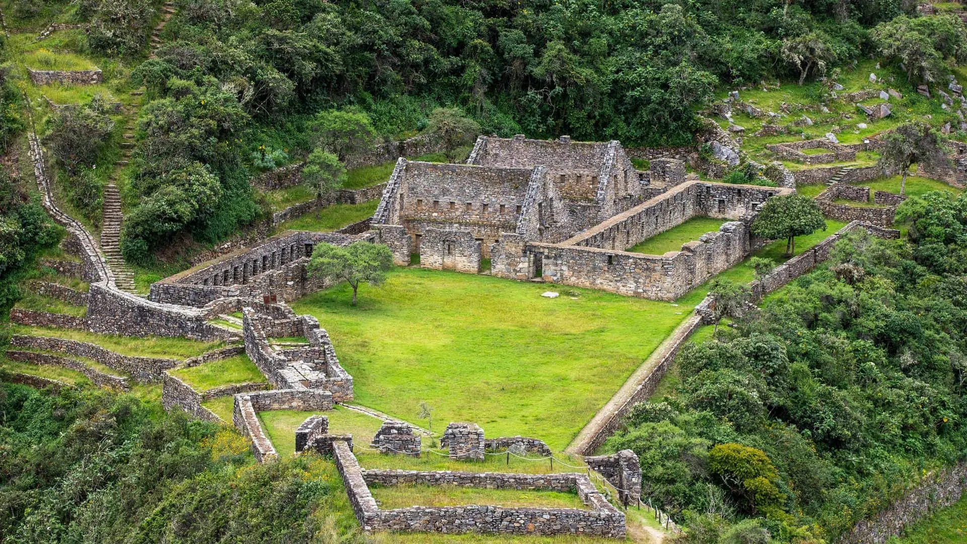
Key facts
- Choquequirao is a great Inca citadel, now an archaeological park, in Santa Teresa District (La Convención, Cusco), above the Apurímac River.
- It sits at an elevation of about 3,050 m, but the trail drops more than 1,000 m to the bottom of the canyon and climbs back up.
- The only way in is on foot: the out-and-back trek starts in Cachora (Apurímac), about 4 h from Cusco, and takes 4 to 5 days.
- Its terraces with 24 white stone llamas are unique in the Andes; it gets about 8,000 visitors a year.
- The cable car is still a project with no date for operation; entry is a Ministry of Culture ticket, and it’s worth confirming the price before you set out.
Choquequirao is a great Inca citadel above the Apurímac River canyon, in the Cusco Region, at an elevation of about 3,050 m. It’s called the “sacred sister” of Machu Picchu, but it gets only a tiny fraction of its visitors, because there’s no road or train: the only way in is on foot, on a 4- to 5-day out-and-back trek from the village of Cachora, about four hours from Cusco. It’s the most demanding trek in the region and one of the most rewarding.
In this guide you’ll find where Choquequirao is, how to get there, what the hike is like, what to see in the archaeological park, its history, the status of the cable car project and when to go. If you’re choosing between several treks, our Machu Picchu treks compared guide puts Choquequirao alongside the others.
Choquequirao at a glance
| Fact | Choquequirao |
|---|---|
| What it is | An Inca citadel, today the Choquequirao Archaeological Park |
| Meaning | “Cradle of gold,” in Quechua |
| Location | Santa Teresa District, La Convención Province, Cusco, above the Apurímac River and on the border with the Apurímac Region |
| Elevation | About 3,050 m |
| Usual access | On foot from Cachora (Apurímac), about 4 h from Cusco by road |
| Trek length | 4 to 5 days, out and back |
| Difficulty | Very challenging: down into and up out of a deep canyon, twice |
| Visitors | About 8,000 a year, according to Mincetur, Peru’s tourism ministry |
| Best season | April to October |
| Entrance fee | A Ministry of Culture ticket; confirm the current rate before you set out |
Where is Choquequirao?
Choquequirao is in the western part of the Cusco Region, in Santa Teresa District, La Convención Province. It sits on a spur of the Vilcabamba mountain range, on the right bank of the Apurímac River, which here runs through a very deep canyon and marks the border with the Apurímac Region. That’s why, even though the site is in Cusco, the usual access starts on the Apurímac side.
The citadel is part of the Choquequirao Regional Conservation Area, created in December 2010 with 103,814 hectares in the districts of Santa Teresa and Vilcabamba (La Convención) and Limatambo and Mollepata (Anta). The area protects the forests and wildlife around the site, as well as the archaeological remains.
Choquequirao elevation
The core of the citadel sits at about 3,050 m, an elevation similar to Cachora’s and a bit lower than the city of Cusco. The problem isn’t the altitude but the elevation change: between Cachora and the citadel, the trail drops more than 1,000 m to the Apurímac River and climbs the same amount back up the other side.
How to get to Choquequirao
There’s no road to the citadel. Today the only practical access is on foot, and almost everyone starts in Cachora.
- Cusco → Cachora: about 4 hours on the highway to Abancay, via Limatambo and Curahuasi, with a final turnoff to Cachora.
- Cachora → Capuliyoc viewpoint: the first stretch, with your first view of the Apurímac canyon.
- Capuliyoc → Apurímac River: a long descent with no shade, via Chiquisca, to Playa Rosalina and the bridge over the river.
- Apurímac River → Marampata: the toughest climb of the trek, via Santa Rosa, up to the hamlet of Marampata.
- Marampata → Choquequirao: a gentler stretch of about two hours to the citadel.
You return the same way. On the 4-day plan, on day two you reach Marampata or the citadel, on day three you visit the site and start back, and on day four you climb to Capuliyoc and return to Cusco. With 5 days you get a full day for the citadel and spread out the descent better.
Choquequirao by public transportation
You can go on your own by bus from Cusco to Abancay, get off at the turnoff for Cachora and continue by taxi or shared van (colectivo). In Cachora there are guesthouses, and you can hire muleteers with mules. It’s possible to do the trek without an agency, but we recommend going with a guide or a muleteer if you don’t have experience on long treks: the heat in the canyon and the lack of water on some stretches are easy to underestimate.
Important: there are no ATMs along the route. Bring enough cash for the entrance fee, meals at the campsites and the mules. The ticket price can change, so confirm it with the Cusco office of the Ministry of Culture (DDC Cusco) or your operator before you set out.
What to see at Choquequirao
Choquequirao spreads across several slopes and ridges, and much of it is still covered by vegetation. Researchers agree that far less of it has been excavated than at Machu Picchu, so a visit combines restored sectors with areas still under the forest.
- The main plaza and its buildings: one- and two-story stone structures, with niches and doorways in the Inca style.
- The usnu: a ceremonial platform on top of a hill, looking out over snowcapped peaks and the canyon.
- The canals and fountains: a hydraulic system that carries water down into the citadel from higher up.
- The terraces: long series of agricultural terraces stepping down the mountain toward the river.
- The stone llamas: the most famous group, described below.
The llamas of Choquequirao
On the walls of one set of terraces there are 24 llama figures made of white stones set into the dark wall, which seem to be climbing up the terraces. Archaeologists uncovered them around 2005, and archaeologist Gori Tumi Echevarría considers them unique in the Andes. Reaching them means descending a good way from the core of the citadel, so save some time and energy for them.
History of Choquequirao
Choquequirao was an important Inca center; researchers attribute religious functions to it, as well as a role in controlling the territory between the Andes and the Vilcabamba jungle. After the Spanish conquest it was left in a hard-to-reach area, but it never disappeared completely from the records: its walls bear inscriptions by travelers such as Eugène de Sartiges, from 1834, and by other visitors from 1861.
Hiram Bingham made the first scientific description of it in 1909, two years before reaching Machu Picchu. He was drawn by the idea that it might be Vilcabamba, the capital of the last Incas who resisted the Spanish, a theory that was later ruled out. Modern archaeological work began in the late 20th century, driven by Plan COPESCO, a government tourism program, and continued through the 2000s.
The Choquequirao cable car
For more than a decade, a cable car has been planned that would take visitors to the citadel in minutes. It’s a public-private partnership promoted by ProInversión, Peru’s private investment promotion agency, with one section from the Apurímac side and another from the Cusco side. In April 2026, the project was still at the tender stage and ProInversión expected to award it at the end of that year.
In practice, today there’s no cable car and no date for it to start operating. If you want to see Choquequirao as it is now, with few visitors, you’ll have to walk.
Choquequirao to Machu Picchu
The usual Choquequirao trek doesn’t reach Machu Picchu: it’s out and back. There are variants that continue from the citadel over high-mountain passes to link up with the Santa Teresa and Hidroeléctrica area, finishing in Aguas Calientes. These are expeditions of around a week, longer and tougher than the Salkantay, and they’re best done with a support team. The final stretch is the same as the Hidroeléctrica route.
Difficulty and preparation
Choquequirao is the toughest trek in the area, even though it doesn’t go above about 3,050 m. You go down into and climb out of a deep canyon twice, with long zigzag stretches, lots of sun and little shade on the lower section.
- Heat and water: it’s hot at the bottom of the canyon. Start very early, carry at least two liters of water and some way to purify it.
- Knees: the descent to Playa Rosalina is long. Trekking poles help a lot.
- Mules: hiring a mule to carry your load makes the trek much more manageable.
- Acclimatization: spend at least two days in Cusco before setting out. More in altitude sickness in Cusco.
This is general information, not medical advice: see your doctor before a multi-day trek if you have heart, respiratory or knee problems.
Best time to go
From April to October, in the dry season, the trail is firm and the canyon is clear; the middle of the day is very hot on the lower section. From November to March, rain makes the trail slippery and can cause landslides. Check Cusco weather by month.
Tip: Choquequirao has no daily quota, but services in Marampata and at the campsites are basic. If you’re going on your own, bring backup food and a headlamp, and let people in Cachora know when you plan to return.
What to bring
- A tent and sleeping bag, if you’re not going with an agency.
- Light clothes for the canyon and warm layers for the nights in Marampata.
- A sun hat, sunscreen and insect repellent.
- Broken-in boots and sandals for camp.
- Water purification tablets or a filter.
You’ll find the full list for the region in our Cusco packing list.
Summary: is Choquequirao right for you?
- Yes: if you’ve already been to Machu Picchu, have experience on long treks and are looking for a great Inca site with almost no crowds.
- Better to choose another route: if it’s your first trek or your goal on this trip is to see Machu Picchu. Look at the Inca Trail or the Salkantay.
To work out how many days and how much money you need, see our Cusco trip budget and our Cusco itinerary.
Frequently asked questions
Where is Choquequirao, Peru?
In Santa Teresa District, La Convención Province, Cusco Region, on the right bank of the Apurímac River. The usual access starts in Cachora, on the Apurímac side.
How do you get to Choquequirao from Cusco?
By road to Cachora, in about four hours, and from there on foot: you descend to the Apurímac River and climb up to Marampata and the citadel. The way in takes about two days.
What is the elevation of Choquequirao?
The core of the citadel is at about 3,050 m. The challenge is the canyon’s elevation change, not the altitude.
How many days do you need for Choquequirao?
Between 4 and 5 days out and back from Cachora. With 5 days you have a full day to explore the citadel and the stone llamas.
Is there a cable car to Choquequirao yet?
No. In April 2026 the project was still out to tender and ProInversión expected to award it at the end of that year. For now, the only way to get there is on foot.
Can you hike from Choquequirao to Machu Picchu?
Yes, but not on the usual trek. The variants that link up with Santa Teresa and Hidroeléctrica are expeditions of around a week.
What does Choquequirao mean?
It’s usually translated from Quechua as “cradle of gold.” It’s also known as the sacred sister of Machu Picchu.
What is the Choquequirao Regional Conservation Area?
A protected area created in 2010, covering about 103,814 hectares, that surrounds the citadel in the provinces of La Convención and Anta and conserves its forests and wildlife.
Official sources
- La República: the llamas of Choquequirao (November 8, 2020) larepublica.pe
- National Geographic: these remote Inca ruins rival Machu Picchu (October 31, 2022) nationalgeographic.com

How we put this guide together
Written by Paul Pumalloclla · 17 years in tourism
- Official sources Prices, opening hours and rules checked against Peru’s Ministry of Culture, SERNANP, PromPerú and the train and bus operators.
- Sources cited Every guide links to the sources we used at the end.
- Always up to date When a rule changes, we update the guide and its date.
We’re not a travel agency: we don’t sell tours or take bookings. If a link belongs to a commercial partner, we label it next to the link, and that never changes the facts or the recommendations.
Guide history
- Published
- Last reviewed
Spotted something out of date?
Let us know and we’ll check it against the official source.
Report a change
