Key facts
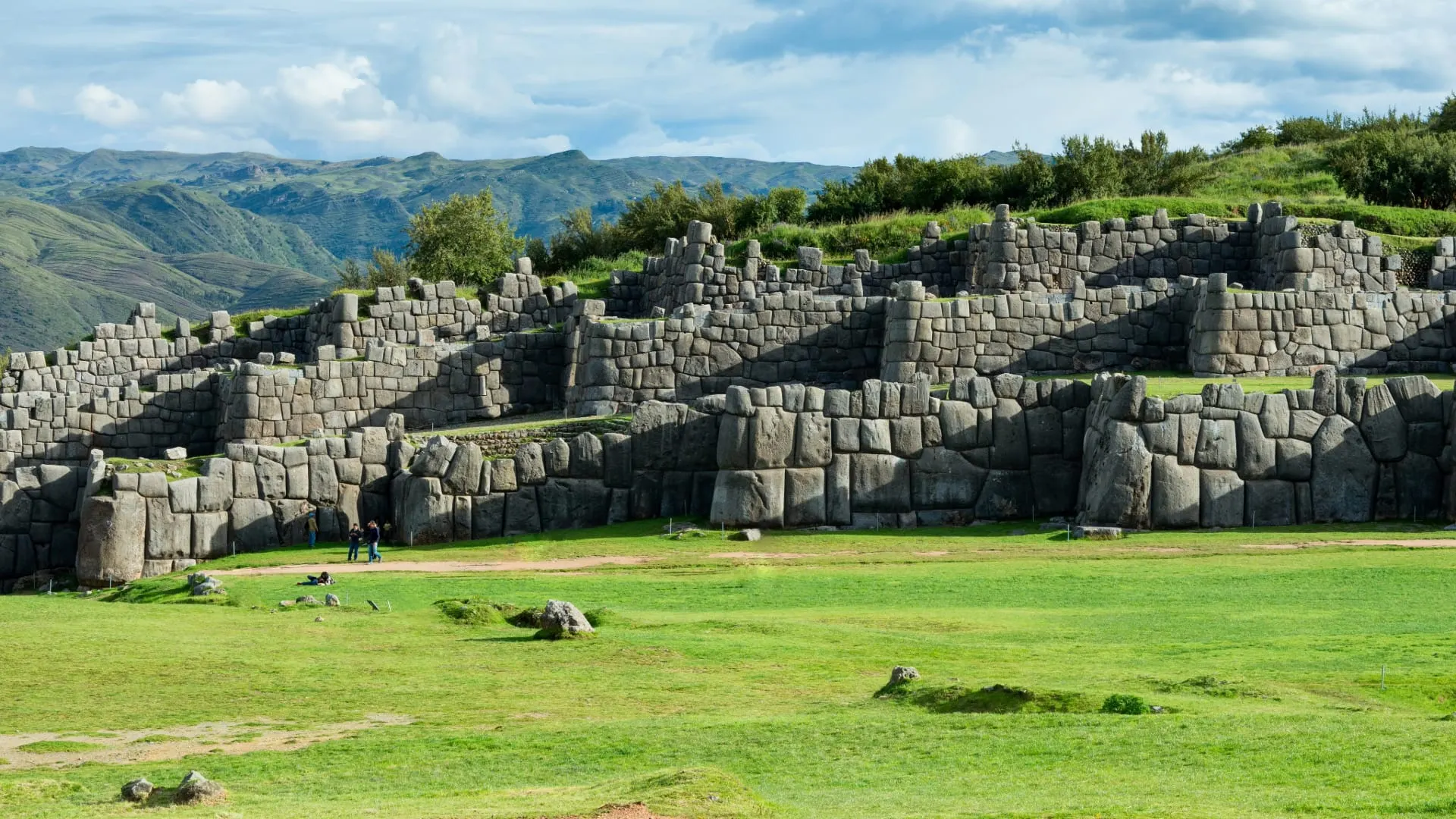
- An Inca ceremonial and military complex with three zigzag walls made of blocks weighing more than 100 tons.
- It’s about 2 km north of the Plaza de Armas, at an elevation of about 3,600 m according to Peru’s Ministry of Culture.
- You can walk up in 30 to 40 minutes via San Cristóbal or take a taxi in about 10 minutes.
- Admission only with the Cusco Tourist Ticket: the Circuit I partial ticket (S/ 70 for foreigners) or the full ticket (S/ 130).
- Open every day from 7:00 a.m. to 5:30 p.m.; the most complete official route takes about 90 minutes.
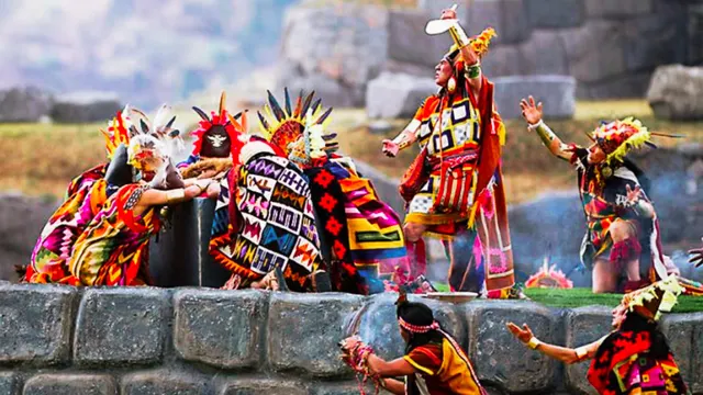
- Every June 24 it’s the stage for the main Inti Raymi ceremony.
Sacsayhuamán is the great Inca complex that looms over Cusco from a hill north of the city, about 2 km from the Plaza de Armas and at an elevation of about 3,600 m. It’s famous for its three zigzag walls, built from stone blocks weighing more than 100 tons fitted together without mortar, and for being the main stage of Inti Raymi every June 24. Admission isn’t sold on its own: it’s included in the Cusco Tourist Ticket.
Important: there’s no individual ticket for Sacsayhuamán. The minimum is the Circuit I partial ticket, which also includes Qenqo, Puka Pukara and Tambomachay. You can buy it at the site’s own ticket booth or at the Cosituc counter on Avenida El Sol.
What Is Sacsayhuamán?
Sacsayhuamán was one of the great ceremonial and military centers of the Inca capital. The chroniclers described it as a fortress because of its walls and towers, but it also had temples, storehouses and spaces for large gatherings. In the symbolic layout of Cusco in the shape of a puma, tradition places Sacsayhuamán at the animal’s head.
Today it’s much more than the esplanade and the walls most visitors see. Sacsayhuamán Archaeological Park covers about 2,997 hectares and brings together 96 archaeological sites, including Qenqo, Tambomachay and Puka Pukara. It was declared Cultural Heritage of the Nation by Law 23765 of July 1982, and it’s part of the City of Cusco area, inscribed as a World Heritage Site by UNESCO in 1983.
Sacsayhuamán, Saqsaywaman or Sacsahuamán?
All three spellings refer to the same place. “Sacsayhuamán” is the traditional Spanish spelling and the most widely used. “Saqsaywaman” is the Quechua spelling used by Peru’s Ministry of Culture and on many signs at the site, and the Tourist Ticket uses “Saqsayhuamán.” “Sacsahuamán” is an old variant. The name is usually translated as “satisfied falcon,” although there are other interpretations.
Where It Is and Sacsayhuamán’s Elevation
It’s in the upper part of the city, above the San Cristóbal neighborhood, about 2 km north of the Plaza de Armas. From the walls you can see much of Cusco, and the Cristo Blanco viewpoint is a few minutes’ walk away.
Sacsayhuamán’s elevation is around 3,600 m (about 11,800 ft). The park’s Master Plan, approved by Peru’s Ministry of Culture in 2024, puts the walls at 3,591 m and the Rodadero at 3,607 m, and describes the Sacsayhuamán plateau as lying between 3,600 and 3,700 m; that’s why many guides round it up to 3,700 m. It’s about 200 m higher than the Plaza de Armas, which sits at about 3,399 m. It doesn’t sound like much, but you feel it on the walk up, especially if you arrived in Cusco a day or two ago. If that’s you, take a taxi up and walk down, and read our guide to altitude sickness in Cusco.
Elevation of Sacsayhuamán and the Other Circuit I Sites
The Master Plan gives the elevation of each sector of the park. That way you know how much you’ll climb if you do the whole circuit:
| Place | What it is | Elevation |
|---|---|---|
| Sacsayhuamán walls | The three zigzag terraces facing the esplanade | 3,591 m |
| Rodadero (Suchuna) | Polished rock with the Inca’s Throne, facing the walls | 3,607 m |
| Qenqo Grande | Shrine carved into the rock, next to the road to Pisac | 3,603 m |
| Puka Pukara | Rooms, terraces, fountains and channels at a spot with wide views | 3,786 m |
| Tambomachay | Fountains and channels of the water cult | 3,805 m |
Sacsayhuamán and Qenqo are at almost the same height, and Tambomachay is the highest point on the circuit, about 200 m above the walls. That’s why it makes sense to start at the top and walk down.
History of Sacsayhuamán
The hill was already occupied centuries before the empire, but the great work you see today is Inca. According to the sources, construction began in the 15th century, in the time of Pachacútec, and was continued by Túpac Yupanqui, Huayna Cápac and Huáscar. It was, therefore, the work of several generations.
Who Built Sacsayhuamán and How?
It’s one of the most searched questions about the site. The short answer: the Incas built it, with thousands of workers sent in shifts from the provinces of the empire. The chronicler Pedro Cieza de León wrote that 20,000 men were requested, of whom about 4,000 quarried the stone and about 6,000 hauled it with ropes. The quarries were several kilometers away; Andina places them about 20 km off.
The blocks were carved and adjusted one by one until they fit without mortar. Theories about “lost builders” or mysterious techniques have no archaeological backing: what you see is the result of organization, massive manpower and a great deal of stonemasonry experience.
Fortress or House of the Sun?
The name “fortress” comes from the Spaniards. Cieza de León, quoted in the park’s Master Plan, wrote that the locals called this place the “house of the sun” and the Spaniards called it a “fortress.” The Ministry of Culture document explains that the military image stuck because Manco Inca turned the House of the Sun into a stronghold during the great siege of 1536. The same Master Plan notes that, according to the chroniclers, work began between the late 14th and early 15th centuries and lasted about 60 years.
The Battle of 1536
In May 1536, during the siege of Cusco, Manco Inca’s troops occupied Sacsayhuamán to surround the Spaniards who controlled the city. The Spaniards stormed it and took it back after several days of fighting; during the assault on the walls, a stone struck Juan Pizarro, Francisco’s brother, on the head, and he died days later.
After the conquest, Sacsayhuamán was used as a quarry: many of its stones, especially the smaller, more manageable ones, ended up in colonial houses and churches in Cusco. That’s why only part of the original structure survives today, and what still stands is mostly the blocks nobody could move. Andina estimates that about 30% of the original construction survives today.
What Recent Research Reveals
Sacsayhuamán is still being studied. An international project led from the University of Warsaw, “The Origins of the Capital of the Incas,” has surveyed about 69 hectares of the area with LiDAR drones and ground-penetrating radar and identified terraces, roads, structures and possible quarries hidden under the vegetation, according to an April 2026 announcement from Italy’s National Research Council, which takes part in the study.
In October 2026, the Italian news agency AGI reported that radiocarbon dates from that team, which includes Peruvian archaeologists, place the start of the site’s monumental transformation around the year 1400, with more construction from 1418 on: some four decades before the traditional date for the start of Pachacútec’s reign. The results are still being prepared for publication, so treat them as a hypothesis under study, not a settled date.
What to See at Sacsayhuamán
The usual visit focuses on the monumental area, with four sectors: the bastions or walls, Muyucmarca, the Rodadero and the Chincana. Allow an hour and a half to two hours to see them at a relaxed pace.
The Walls of Sacsayhuamán
They’re three stacked terraces of zigzag walls, which the Ministry of Culture calls the Baluartes (bastions). According to Andina, the platforms average about 360 m in length and are connected by stairways and gates. The biggest stones are in the first wall: the park’s Master Plan estimates they can weigh between 90 and 125 tons. Look closely at the joints: there’s no mortar, and the faces of the stones fit against each other at irregular angles. The zigzag isn’t decorative; it made it possible to see and attack anyone approaching from any angle.
The Three Gates
Each wall had a gate near its center. The Inca Garcilaso de la Vega, quoted in the Master Plan, gave their names: Tiupuncu, the “gate of the sandy ground,” because it faced the sandy plain in front; Acahuana Puncu, in memory of the master builder who made it; and Viracocha Puncu, dedicated to the god Viracocha. One of today’s visitor routes goes down through that first gate, which the Master Plan spells Tiopunku.
Muyucmarca and the Towers
Up top, above the walls, stood the three towers described by the chroniclers. The main one, Muyucmarca, was round and, according to those chronicles, had a fountain fed by water brought underground; the other two, Paucarmarca and Sallacmarca, were square. They were dismantled in colonial times. Today you can see the foundations of one circular and two rectangular structures, plus five carved rocks around which ceremonial plazas were arranged, according to the Master Plan. They help you picture the scale of the complex.
The Esplanade
Between the walls and the hill opposite lies a large esplanade, the Chukipampa. Great ceremonies were held here, and this is where the main part of Inti Raymi, the Festival of the Sun, is staged every June 24.
The Rodadero, the Inca’s Throne and the Chincana
Facing the walls, on the other side of the esplanade, is the Rodadero: a large outcrop of polished rock with natural grooves that kids use as a slide. On top are seats carved into the rock, known as the Inca’s Throne. The Ministry of Culture calls this sector Suchuna: it’s a diorite outcrop with a stairway and terraces, and the constant friction of visitors has worn down its surface.
Nearby is the Chincana Chica, a narrow crevice about 20 m long between the rocks that many visitors walk through. Farther north, about 450 m from the esplanade, is the Chincana Grande, with seats, niches, stairways and animal figures carved into the rock.
Tip: climb the Rodadero for the best photo of the three zigzag walls. From below you see the scale of the stones; from above, the full layout.
Qocha, the Great Circular Reservoir
About 250 m north of the esplanade is Qhapaq Qocha, better known as Qocha: a large circular structure, with niches in its wall, that served as a reservoir. Channels carved into the rock and fountains fed into it. Next to it are rooms of fine stonework and rocks with carved steps and niches. Of the official visitor routes, only the full one comes this way.
What to See in Order: The Official Routes
The Master Plan describes three routes through the monumental area. They all start at the ticket checkpoint, in the Llaullipata sector, and end at Puqro, where the parking area is; you can also do them in reverse.
| Route | Where it goes | Approximate time |
|---|---|---|
| Short | The esplanade, with views of the walls and the Rodadero, and exit via Puqro | 30 minutes |
| Medium | The esplanade, up the walls to Muyucmarca and Sayaqmarka, a viewpoint over Cusco, down through the Tiopunku gate and exit via Puqro | 60 minutes |
| Full | The medium route plus the Rodadero (Suchuna) and Qocha, with exit via Puqro | 90 minutes |
The short route is the one older visitors and people with limited mobility usually take. If this is your only visit to Sacsayhuamán, the full route is the most rewarding: it’s the only one that includes the Rodadero and Qocha, and it also gives you the view of the esplanade from above.
Sacsayhuamán Admission and Hours
You can only enter with the Cusco Tourist Ticket. These are the options that work for Sacsayhuamán, according to Cosituc’s fare list:
| Ticket | What it includes | Validity | Foreigners | Peruvians or residents |
|---|---|---|---|---|
| Saqsayhuamán partial ticket (Circuit I) | Sacsayhuamán, Qenqo, Puka Pukara and Tambomachay | Foreigners: 5 days. Nationals: 1 day | S/ 70 | S/ 40 |
| Full ticket | 16 sites in Cusco, the Sacred Valley and the South Valley | 10 days | S/ 130 | S/ 70 |
| Full student ticket | 16 sites, with a university ID or ISIC card | 10 days | S/ 70 | S/ 40 |
Fares checked on October 31, 2026. Confirm them on the official channel before you buy.
If you’re also going to see the Sacred Valley or the South Valley, the full ticket works out cheaper than two partial tickets. Keep in mind that validity starts on the day of purchase, so don’t buy it before the day you start your visits.
Sacsayhuamán is open every day, from 7:00 a.m. to 5:30 p.m. Bring your ID: the ticket is issued in your name and they ask for it at the checkpoint.
How to Get to Sacsayhuamán from the Plaza de Armas
- On foot: a 30- to 40-minute climb up the Cuesta del Almirante or Calle Suecia, past San Cristóbal Church. It’s steep and at high altitude.
- By taxi: about 10 minutes on the road that circles the city. It’s the best option if you’ve just arrived.
- By public transportation: according to the Master Plan, there are city bus lines that go up the Cusco–Pisac road as far as Qenqo, near Sacsayhuamán, and others that continue farther up the same road.
- Walking down from Tambomachay: take a taxi to Tambomachay and Puka Pukara, about 7.5 km away, and walk back downhill past Qenqo and Sacsayhuamán to the center.
- On a city tour: Cusco agencies offer a half-day tour of the Qorikancha and the four Circuit I sites, usually in the afternoon. Check whether the price includes the Tourist Ticket.
Tip: the downhill route from Tambomachay is the easiest way to see the four Circuit I sites on your own. Start early to reach Sacsayhuamán before the afternoon groups arrive.
Best Season and Best Time to Visit
Sacsayhuamán can be visited all year. From May to September, the dry season, you’ll get blue skies and good light, but also more visitors, especially in June because of Inti Raymi. From December to March it often rains in the afternoon and the grass on the esplanade gets slippery. Month-by-month details in our guide to Cusco weather.
The best time is first thing in the morning, when it opens, or late in the afternoon, with low-angled light on the stones. Most city tour groups arrive in mid-afternoon.
Don’t expect to have it to yourself. According to the Master Plan, Circuit I received more than 1.2 million visits in 2015, and the number of visitors grew by 70% between 2010 and 2018.
Sacsayhuamán During Inti Raymi
Every June 24, the main Inti Raymi ceremony takes place on the esplanade, in front of the walls, starting at midday. The grandstands with numbered seats are paid and sell out before the big day; you can also watch for free from the hillsides, from a distance and with many hours in the sun. That day, access changes completely. All the logistics are in our guide to Inti Raymi.
To protect the site, Cusco’s regional culture office closes off some areas with railings. In 2023, according to Andina, the Chincana Grande, the Chincana Chica, Qocha, the Baluartes esplanade, Calispuquio and Puqro were off-limits, while access to Suchuna and the Cruz del Papa was allowed, always following staff instructions. Climbing the walls, lighting fires, littering and graffiti are prohibited. If you plan to watch from the hillsides, check which areas are open that year.
Tips for Your Visit
- Bring sunscreen, a hat and water: there’s almost no shade in the monumental area.
- Wear shoes with good soles. The rocks of the Rodadero and the grass are slippery, especially in the rain.
- Don’t climb or sit on the walls: they’re protected heritage, and the guards keep an eye on it.
- Bring a warm layer. If it clouds over, the temperature drops fast on the hill.
- Carry some cash in soles in case the ticket booth doesn’t take cards.
- If you’re traveling with kids, they’ll love the Rodadero, but keep an eye on them: there are drops without railings.
Next Step: What to Combine with Sacsayhuamán
- Half a day on your own: Tambomachay, Puka Pukara, Qenqo and Sacsayhuamán, downhill, ending on foot in the San Blas neighborhood.
- A full day in the city: the Qorikancha temple in the morning, lunch in the center and Sacsayhuamán in the afternoon.
- To plan your whole trip: fit the visit into your Cusco itinerary, from the second day on, and see more ideas in things to do in Cusco.
If it’s your first time in the city, start with our general Cusco guide and save Sacsayhuamán for when you’re acclimatized.
Bottom Line: Sacsayhuamán for Every Traveler
- You have an hour: the medium route, with the walls, Muyucmarca and the viewpoint over Cusco.
- You have half a day: a taxi to Tambomachay and a walk down past Puka Pukara, Qenqo and Sacsayhuamán with the Circuit I partial ticket.
- You’ve just arrived in Cusco: go up by taxi, do the short route across the esplanade and save the walk for when you’re acclimatized.
- You’re into history: the full route, with the Rodadero and Qocha, and look for the three gates in the walls.
- You’re traveling in June: on the 24th access changes and areas close; plan it with the Inti Raymi guide.
Frequently asked questions
Where is Sacsayhuamán?
On a hill north of Cusco’s historic center, about 2 km from the Plaza de Armas, above the San Cristóbal neighborhood.
How much does it cost to visit Sacsayhuamán?
There’s no individual ticket. For foreigners, the Circuit I partial ticket costs S/ 70 and includes three other sites; the full Tourist Ticket costs S/ 130. Peruvians and residents pay S/ 40 and S/ 70.
Who built Sacsayhuamán?
The Incas. According to the chroniclers, work began under Pachacútec and was continued by his successors, with thousands of workers sent in shifts from the provinces. Recent radiocarbon dates, still awaiting publication, place the start of the great construction around the year 1400.
What does Sacsayhuamán mean?
It’s a Quechua name usually translated as “satisfied falcon.” Saqsaywaman is the Quechua spelling used by Peru’s Ministry of Culture.
How much do the stones of Sacsayhuamán weigh?
The largest blocks, in the first wall, can weigh between 90 and 125 tons, according to the Ministry of Culture’s Master Plan and Andina.
Can you walk to Sacsayhuamán?
Yes. From the Plaza de Armas it’s a steep 30- to 40-minute climb. If you’ve just arrived in Cusco, take a taxi up and walk down.
How much time do you need at Sacsayhuamán?
An hour and a half to two hours for the walls, the esplanade and the Rodadero. With Qenqo, Puka Pukara and Tambomachay, half a day.
What are Sacsayhuamán’s opening hours?
It’s open Monday to Sunday, from 7:00 a.m. to 5:30 p.m. On June 24, access changes because of Inti Raymi.
What is the elevation of Sacsayhuamán?
About 3,600 m. The Ministry of Culture’s Master Plan puts the walls at 3,591 m and the Rodadero at 3,607 m, about 200 m above the Plaza de Armas. Many guides round it up to 3,700 m.
What routes are there inside Sacsayhuamán?
The Ministry of Culture describes three: a short one of about 30 minutes across the esplanade; a medium one of 60 minutes, with the walls, Muyucmarca and a viewpoint; and a full one of 90 minutes that adds the Rodadero and Qocha.
How many days is the Sacsayhuamán partial ticket valid?
For foreigners, 5 days for S/ 70; for Peruvians, 1 day for S/ 40, according to Cosituc. It covers Sacsayhuamán, Qenqo, Puka Pukara and Tambomachay.
Which areas of Sacsayhuamán close during Inti Raymi?
Cusco’s culture office closes off areas such as the chincanas, Qocha and the Baluartes esplanade with railings. In 2023, access to Suchuna and the Cruz del Papa was allowed, following staff instructions.
Official sources
- Cosituc: Cusco Tourist Ticket fares cosituccusco.pe
- Cosituc: Sacsayhuamán Archaeological Park cosituccusco.pe
- UNESCO: City of Cuzco, World Heritage whc.unesco.org
- Wikipedia: Siege of Cusco (1536) en.wikipedia.org

How we put this guide together
Written by Paul Pumalloclla · 17 years in tourism
- Official sources Prices, opening hours and rules checked against Peru’s Ministry of Culture, SERNANP, PromPerú and the train and bus operators.
- Sources cited Every guide links to the sources we used at the end.
- Always up to date When a rule changes, we update the guide and its date.
We’re not a travel agency: we don’t sell tours or take bookings. If a link belongs to a commercial partner, we label it next to the link, and that never changes the facts or the recommendations.
Guide history
- Published
- Last reviewed
Spotted something out of date?
Let us know and we’ll check it against the official source.
Report a change