Key facts
- Aguas Calientes, officially Machupicchu Pueblo, is the capital of the Machupicchu district (Urubamba province) and the base town for visiting the Inca city.
- It sits at 2,040 m, almost 1,400 m lower than Cusco and about 400 m below Machu Picchu, some 8 km away by road.
- It grew up around the train station: Law 9396 created the district in 1941, and tourism took it from 2,298 residents in 1993 to 5,286 in 2007.
- You can only get there by train from Ollantaytambo or Cusco, or on foot from Hidroeléctrica or at the end of a trek; the bus up to the citadel takes 25 to 30 minutes.
- The Machupicchu Thermal Baths have water at 32 to 37 °C and are open from 5:00 a.m. to 7:30 p.m.; the Manuel Chávez Ballón Site Museum is open from 9:00 a.m. to 4:00 p.m.
- Most rain falls from January to March and the town is exposed to mudslides: leave some slack in your trip during the rainy season.
Aguas Calientes, officially named Machupicchu Pueblo, is the town in Cusco, Peru, at the foot of Machu Picchu, at an elevation of 2,040 m (about 6,690 ft), almost 1,400 m lower than the city of Cusco. You can only get there by train or on foot, because there’s no open road from Cusco, and it’s where the trains end and the buses leave for the 25- to 30-minute ride up to the Inca city. It has hotels, restaurants, the hot springs that give the town its name, a site museum and several walks for an afternoon or a morning.
Where Is Aguas Calientes?
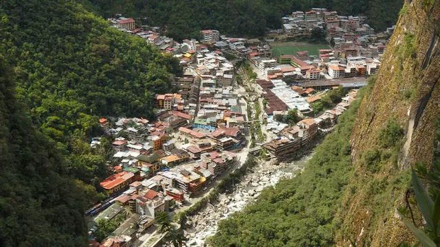
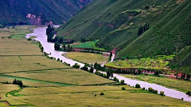
Aguas Calientes is the capital of the Machupicchu district, in Urubamba province, Cusco region. It lies at the bottom of the Vilcanota (Urubamba) River canyon, where the Aguas Calientes River joins it, surrounded by forest-covered mountains. The Inca city sits about 400 m higher up, roughly 8 km along the switchback road the buses take.
- Elevation: 2,040 m, almost 1,400 m lower than Cusco. The climate is warm and humid, with frequent rain from November to March.
- Access: by train from Ollantaytambo or Cusco, on foot from Hidroeléctrica or at the end of a trek. Private cars don’t drive through the town.
- Size: you can walk across it in a few minutes. Almost everything is between the train station, the main square and Avenida Hermanos Ayar, along the river.
If you search for “Aguas Calientes, Peru” or “Machu Picchu town,” it’s the same place: the base town for visiting Machu Picchu.
Official Name and District
The legal name is Machupicchu Pueblo, capital of the Machupicchu district. “Aguas Calientes” (“hot waters”) is the popular name, shared by the river that runs through town and by its hot springs. The district has one unusual feature: according to the Master Plan for the Historic Sanctuary of Machupicchu, its boundaries match the sanctuary’s almost exactly. In other words, the whole town lies inside a protected natural area that is also an archaeological park, and that shapes how and where it can grow.
Aguas Calientes Elevation
The official map from the municipality and PromPerú puts Machupicchu Pueblo at 2,040 m above sea level. That’s almost 1,400 m lower than Cusco (3,399 m) and about 400 m lower than the Inca city. At that elevation altitude sickness is barely noticeable, and many travelers sleep better here than in Cusco. Here’s how the town compares with the places you’ll visit:
| Place | Elevation | Compared with the town |
|---|---|---|
| Cusco (city) | 3,399 m (11,152 ft) | Almost 1,400 m higher |
| Ollantaytambo | 2,792 m (9,160 ft) | About 750 m higher |
| Putucusi Mountain | 2,560 m (8,399 ft) | About 520 m higher |
| Machu Picchu (Inca city) | 2,430 m (7,972 ft) | About 400 m higher |
| Machupicchu Thermal Baths | 2,080 m (6,824 ft) | 40 m higher |
| Machupicchu Pueblo (Aguas Calientes) | 2,040 m (6,693 ft) | — |
| Manuel Chávez Ballón Site Museum | 1,977 m (6,486 ft) | About 60 m lower |
| Mandor Gardens | 1,860 m (6,102 ft) | 180 m lower |
Elevations for the town, the hot springs, the museum and Mandor come from the map “Machupicchu Pueblo y sus otras maravillas” (District Municipality of Machupicchu and PromPerú). Machu Picchu, according to Peru’s Ministry of Culture; that map gives 2,453 m. Putucusi, according to the municipality as quoted by Andina. If you arrive from Cusco feeling unwell, read altitude sickness in Cusco.
History of Aguas Calientes: From Railroad to Tourism
Aguas Calientes is a young town that was born with the railroad. According to the sanctuary’s Master Plan, from 1929 the only way to reach Machu Picchu was by rail, and a small settlement grew up next to the station. In October 1941, Law 9396 split the area off from the Ollantaytambo district, created the Machupicchu district and made its capital the settlement that had formed “around the current Machupicchu station.”
The big change came with tourism. According to the INEI census figures in the Master Plan, the district grew from 2,298 residents in 1993 to 5,286 in 2007, and 4,446 of them already lived in the urban area, that is, in the town. Many came from other provinces of Cusco and from neighboring regions such as Puno and Apurímac, drawn by jobs in hotels, restaurants and transportation. The same document describes fast, poorly planned urban growth squeezed between the rivers and the slopes, with narrow, steep streets. That’s what you see today as you walk around: buildings several stories high pressed against the mountain, and almost the whole economy geared to visitors.
How to Get to Aguas Calientes
By Train from Cusco or Ollantaytambo
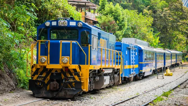
This is the most common way. PeruRail and Inca Rail run mostly from Ollantaytambo, in the Sacred Valley, with rides of 1 h 30 min to 2 h. From Cusco, PeruRail has a direct train from Poroy station, from May to December, taking about 3 h 30 min; the other departures from Cusco combine bus and train. Classes, schedules and luggage allowance in our guide to the train to Machu Picchu.
Tip: only carry-on luggage is allowed on the train. Leave your big suitcase at your hotel in Cusco or at PeruRail’s free luggage storage in Ollantaytambo and Machu Picchu Pueblo, and travel with a backpack for one or two nights.
Via Hidroeléctrica or on Foot
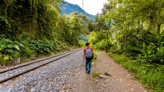
The budget option is to go by road to Hidroeléctrica and walk about 2 h 30 min along the railroad tracks to the town; every leg is covered in the Hidroeléctrica route. Hikers on the Salkantay trek and the short Inca Trail also end up here. We compare every option in how to get to Machu Picchu from Cusco.
From Aguas Calientes to Machu Picchu
- By bus: the Consettur bus runs up from 5:30 a.m. to 3:30 p.m. and down from 6:30 a.m. to 6:00 p.m., taking 25 to 30 minutes. The reference fare for foreign adults is US$24 round trip. The ticket office is on Avenida Hermanos Ayar, before the Puente Ruinas bridge, and is open from 5:30 a.m. to 10:00 p.m.
- On foot: the stone-step trail crosses the Puente Ruinas bridge and climbs up, cutting across the road, to the main gate. Allow about an hour and a half of strenuous climbing.
Schedules, fares by traveler type and how to estimate the line in our guide to the bus to Machu Picchu from Aguas Calientes.
Important: entry to the Inca city isn’t sold on the bus. You need a Machu Picchu ticket with a date, time and route. The Ministry of Culture’s ticket office in town sells up to 1,000 tickets a day, but only for entry the following day; how those in-person sales work is explained in the ticket guide.
Aguas Calientes Hot Springs
The Machupicchu Thermal Baths are the waters that give the town its name. According to the tourist brochure from the District Municipality of Machupicchu and PromPerú, they’re sulfurous waters that rise from the rocky subsoil, with an average temperature of 32 to 37 °C (90 to 99 °F).
- Where they are: in the upper part of town, about a 15-minute walk from the main square, at about 2,080 m, next to the Aguas Calientes River ravine.
- Hours: every day, from 5:00 a.m. to 7:30 p.m.
- Admission: S/ 20 for foreigners, S/ 10 for Peruvians and S/ 5 for district residents (rates in effect in November 2026, confirmed by our team in Cusco). They’re run by the District Municipality of Machupicchu.
- What to bring: swimsuit, towel, sandals and some cash.
It’s a simple outing, not a spa: open-air pools among the mountains, crowded in the late afternoon, when visitors come down from Machu Picchu. If you want peace and quiet, go early in the morning or on the day you arrive. In the rainy season, ask before walking up: the sanctuary’s Master Plan flags an area of rockfall and debris flows in the ravine, about 160 m from the hot springs.
Things to Do in Aguas Calientes
Besides going up to the Inca city, the town and its surroundings are enough for a free afternoon or morning. This table sums up the attractions listed on the town’s official map:
| Attraction | Distance from town | Hours | Admission |
|---|---|---|---|
| Machupicchu Thermal Baths | 15 min walk from the square | 5:00 a.m. to 7:30 p.m. | Paid |
| Craft market | Next to the train station | 7:00 a.m. to 9:00 p.m. | Free |
| Chronicles in Stone circuit | Avenida Hermanos Ayar, Wiñay Wayna park and Calle Torrechayoc | 24 hours | Free |
| “Mariposas de Machupicchu” butterfly house | 1.2 km (20 min walk) | 9:00 a.m. to 5:30 p.m. | Paid |
| Manuel Chávez Ballón Site Museum and Botanical Garden | 2 km (30 min walk), 200 m from the Puente Ruinas bridge | Museum 9:00 a.m. to 4:00 p.m.; garden 9:00 a.m. to 3:00 p.m. | Paid |
| Mandor Gardens (Mandorpampa) | 4.3 km (1 h 30 min walk) | 7:00 a.m. to 6:00 p.m. | Paid |
Data from the brochure “Machupicchu Pueblo y sus otras maravillas,” by the District Municipality of Machupicchu with PromPerú, updated in 2018. Hours may change: confirm them when you arrive.
Manuel Chávez Ballón Site Museum and Botanical Garden
It’s the best visit in town if you want to understand Machu Picchu. It’s named after its first director; the building dates from the 1970s and, after its exhibits were redesigned, it opened to the public on July 25, 2005, according to Andina. It has seven rooms with about 250 pieces found in the Inca city, on the Inca Trail and in the surrounding area: ceramics, stonework, metals and human remains. Behind it is the botanical garden, with more than 400 species of native and cultivated plants, including orchids and ferns.
- Where it is: next to the old Puente Ruinas bridge, at km 112 of the railroad, about 2 km from town. It’s about a 30-minute walk along the road that follows the river toward the Puente Ruinas; keep to the edge, because the buses use it.
- Hours: the Ministry of Culture lists it as open from 9:00 a.m. to 4:00 p.m. The garden, according to the municipal map, closes at 3:00 p.m.
- Admission: paid; one ticket covers the museum and the garden. As a Ministry of Culture museum, it’s part of the Museos Abiertos program, with free admission on the first Sunday of every month.
- Is it included in the Machu Picchu ticket? It isn’t part of the Inca city’s circuits. In 2019, Andina reported that the Machu Picchu ticket gave free entry to the museum from noon on; we haven’t found a more recent official confirmation, so bring your ticket and ask at the booth.
It fits in nicely when you walk down from the Inca city, because the stone-step trail ends at the Puente Ruinas bridge, a few steps from the museum.
Mandor Gardens and Waterfall
Mandorpampa is a 4.3 km walk, about 1 h 30 min on foot, to gardens with fruit trees, orchids, birds and butterflies, and a waterfall with pools. The water comes down from the snowcapped La Verónica peak, and the area sits at 1,860 m, lower than the town. Part of the path runs along the railroad: walk on the edge and away from the rails, because trains pass through there. In January 2026, a mudslide in the Mandor area forced a temporary closure of the footpath between Hidroeléctrica and the town, so ask at iPerú whether the path is open before you set out.
Putucusi: Can You Climb It?
Putucusi is the mountain that rises right next to the town, facing the Inca city, at 2,560 m. The sanctuary’s Master Plan lists it among the area’s hikes, but it isn’t open to visitors today: we confirmed this in November 2026. Back in December 2023, the municipality, quoted by Andina, was working on a project to open access, with objections from the Ministry of Culture still pending. Don’t try to climb it on your own.
Butterfly House, Market, Square and Chronicles in Stone
The butterfly house is a butterfly research and conservation center, with a garden and an area where you can watch their metamorphosis. At the craft market, next to the station, you’ll find textiles and souvenirs. The heart of town is Plaza Manco Ccapaq, around which the municipal map places the town hall and the Virgen del Carmen church. And the Chronicles in Stone circuit brings together 37 granite sculptures on the Andean worldview, spread around the town, which you can see on a stroll.
What to Do with an Afternoon or a Morning
- The afternoon you arrive: buy your bus ticket for the next day, browse the craft market and the Chronicles in Stone, and finish at the hot springs before they close at 7:30 p.m.
- A free morning before your train: walk to the museum and botanical garden, which open at 9:00 a.m. With the walk there and back, allow about 2 h 30 min; if you have time to spare, add the butterfly house.
- The day of your visit: walk down from the Inca city to the Puente Ruinas bridge, stop at the museum and walk back to town.
- Half a day or more: the Mandor Gardens, if the path is open.
Aguas Calientes at Night
Aguas Calientes is a quiet town at night. After 6:00 p.m., when the last bus comes down from the citadel, those left are mostly travelers who are sleeping there and going up to the Inca city the next day. Life centers on the main square and the restaurant streets, and the craft market stays open until 9:00 p.m. The hot springs close at 7:30 p.m., so if you want a late soak, go in before then.
Have an early dinner and pack your backpack: if you have a 6:00 a.m. slot, the bus line forms before the first one leaves, at 5:30 a.m.
Where to Eat and Where to Stay in Aguas Calientes
Where to Eat
There are restaurants for every budget: tourist set menus near the square and the station, Peruvian and international food, and cafés for breakfast before the first buses. The town’s Central Market is the cheapest option for a simple lunch.
- Ask the price before ordering at places with menus posted on the street, especially around the station.
- Everything arrives by train, so eating out usually costs more than in Cusco.
- You can’t eat inside the sanctuary and there’s no food for sale, so have a good breakfast before going up.
Where to Stay
Staying in town makes sense if your ticket is for one of the first slots, if you’re climbing a mountain or if you arrive via Hidroeléctrica or a trek. Lodging ranges from simple hostels to luxury hotels, and in peak season the best ones fill up early.
- Near the station and the square: the most practical if you arrive by train with a backpack and leave the next day.
- Along Avenida Hermanos Ayar: close to the bus office, convenient for the 6:00 a.m. slot.
- Toward the hot springs: quieter streets, a bit more uphill.
If you’re torn between spending the night here, going back to Cusco the same day or sleeping in Ollantaytambo, we compare them with real train, bus and entry times in staying in Aguas Calientes or going back to Cusco the same day?
Weather, Rain and Mudslides in Aguas Calientes
Aguas Calientes lies at the bottom of the Urubamba valley, where the Andes drop toward the Amazon. The sanctuary’s Master Plan, drawn up by SERNANP (Peru’s protected areas agency) and the Ministry of Culture, describes the valley floor, between 1,700 and 2,200 m, as humid, with 1,800 to 2,000 mm of rain a year and an average annual temperature (biotemperature) of 18 to 24 °C (64 to 75 °F). In practice: humid heat during the day, morning mist and possible rain in any month.
- Dry season: April to August, according to the Master Plan, although in the low areas rain is spread more evenly through the year and the odd shower is normal.
- Rainy season: the heaviest rain falls from January to March, and from November it already rains often.
- Humidity and mosquitoes: bring insect repellent, light quick-dry clothes and a rain jacket. The rainy months are covered in Cusco weather by month.
Mudslides: The Rainy-Season Risk
The town sits on the alluvial fan where the steep Aguas Calientes and Alcamayo ravines empty into the Vilcanota. In heavy rain, those ravines can come down loaded with mud and rocks: these are the huaicos, or mudslides. The Master Plan considers Machupicchu Pueblo the most vulnerable spot in the sanctuary and records several events:
- April 2004: a debris flow down the Alcamayo ravine destroyed part of the town and the railroad and killed ten people.
- April 2007 and February 2010: mudslides down the Aguas Calientes ravine hit the town.
- January 2026: according to Andina, a mudslide at Mandor, between km 114 and 115 of the railroad, suspended trains between Machu Picchu and Hidroeléctrica and closed the footpath along that route.
Important: from December to March, follow the notices from the municipality, the Ministry of Culture and the train companies, stay away from riverbeds when it rains hard and leave a spare day in your itinerary. If the line is cut, the train guide explains what to do with your ticket.
Services and Practical Information
- Tourist information: iPerú has an office on Avenida Pachacútec, block 1, in the building of the Decentralized Culture Office, open 9:00 a.m. to 6:00 p.m. every day according to the 2018 map.
- Money: the official map shows banks and ATMs in town, but it’s wise to arrive with soles from Cusco in case one is out of order or has a line. Fees and tips in money in Peru.
- Health and police: the same map marks medical care points and a police station in town.
- Machu Picchu tickets: the Ministry of Culture’s in-person sales are only for the following day; if your date is already set, buy online.
- Luggage: just enough for one or two nights. If you need a list, see our Cusco packing list.
- Elevation: at 2,040 m, the town is a good place to rest if altitude sickness bothered you in Cusco.
Bottom Line: How to Make the Most of Aguas Calientes
- Buy your Machu Picchu ticket first and then the train that gets you to town with time to spare.
- If you’re entering on one of the first slots or climbing Huayna Picchu, book a night in Aguas Calientes.
- On the afternoon you arrive, buy your bus ticket, stroll through the market and relax in the hot springs.
- On the day of your visit, walk down if your legs are up to it and stop by the museum and the botanical garden, next to the Puente Ruinas bridge.
- Remember you’re at 2,040 m: more heat, more humidity and less altitude sickness than in Cusco.
- Between December and March, leave room for the rain and check the state of the railroad and the paths before you set out.
If you want to split your days between Cusco, the Sacred Valley and Machu Picchu, plan them with our 3-, 5- and 7-day Cusco itinerary.
Frequently asked questions
Are Aguas Calientes and Machu Picchu Pueblo the same place?
Yes. Aguas Calientes is the popular name and Machupicchu Pueblo the official one. It’s the town at the foot of the Inca city, where the trains arrive and the buses leave.
What is the elevation of Aguas Calientes?
About 2,040 m (6,690 ft) above sea level, almost 1,400 m lower than Cusco (3,399 m) and about 400 m lower than Machu Picchu. That’s why it’s warmer and more humid, and altitude sickness is hardly noticeable.
Which district and province is Aguas Calientes in?
It’s the capital of the Machupicchu district, in Urubamba province, Cusco region. The district was created by Law 9396 in 1941, and its boundaries almost exactly match those of the Historic Sanctuary of Machupicchu.
How do I get from Cusco to Aguas Calientes?
By train: direct from Poroy from May to December, in about 3 h 30 min, or by road to Ollantaytambo and then a 1 h 30 min to 2 h train ride. The budget alternative is the road to Hidroeléctrica and about 2 h 30 min on foot.
How much do the Aguas Calientes hot springs cost?
S/ 20 for foreigners, S/ 10 for Peruvians and S/ 5 for district residents, as we confirmed in November 2026. They’re run by the District Municipality of Machupicchu, open every day from 5:00 a.m. to 7:30 p.m., and the water is 32–37 °C.
What is there to do in Aguas Calientes besides Machu Picchu?
Soak in the hot springs, visit the Manuel Chávez Ballón Site Museum and its botanical garden, walk to the Mandor Gardens if the path is open, see the butterfly house and stroll through the craft market and the Chronicles in Stone.
Is the site museum included in the Machu Picchu ticket?
It isn’t part of the circuits. In 2019 Andina reported free entry to the museum with the Machu Picchu ticket from noon on, but there’s no recent official confirmation: ask at the booth. On the first Sunday of every month admission is free under the Museos Abiertos program.
Can you climb Putucusi?
No. As of November 2026, Putucusi isn’t open to visitors. The municipality has been working for years on a project to open access, with objections from the Ministry of Culture; don’t climb it on your own.
When does it rain in Aguas Calientes?
It can rain in any month, but the heaviest rain falls from January to March and it’s frequent from November on. In those months mudslides can cut the railroad, so leave some slack in your plans.
Are there ATMs in Aguas Calientes?
Yes, the town’s official map shows banks and ATMs, but it’s wise to arrive with soles from Cusco in case one is out of order or has a line.
Is it worth staying overnight in Aguas Calientes?
Yes, if you’re entering Machu Picchu on one of the first slots, climbing a mountain or arriving via Hidroeléctrica or a trek. You skip the predawn start from Cusco and visit the citadel with fewer people.
Can I buy Machu Picchu tickets in Aguas Calientes?
Yes, but only for the following day. The Ministry of Culture’s ticket office sells up to 1,000 tickets a day in person; for specific dates, buy on the official Tu Boleto portal.
Official sources
- Peru’s Ministry of Culture: in-person ticket sales machupicchu.gob.pe
- PeruRail: train schedules and frequencies perurail.com
- PeruRail: luggage policy perurail.com

How we put this guide together
Written by Paul Pumalloclla · 17 years in tourism
- Official sources Prices, opening hours and rules checked against Peru’s Ministry of Culture, SERNANP, PromPerú and the train and bus operators.
- Sources cited Every guide links to the sources we used at the end.
- Always up to date When a rule changes, we update the guide and its date.
We’re not a travel agency: we don’t sell tours or take bookings. If a link belongs to a commercial partner, we label it next to the link, and that never changes the facts or the recommendations.
Guide history
- Published
- Last reviewed
Spotted something out of date?
Let us know and we’ll check it against the official source.
Report a change