
Key facts
- Tambomachay is an Inca complex devoted to water worship, known as “the Bath of the Inca.”
- It’s about 7.5 km from Cusco on the road to Pisac and is the farthest site on the hillside circuit.
- It sits at 3,805 m, about 400 m above the Plaza de Armas.
- Across from it is Puka Pukara, the “red fortress,” a tambo and checkpoint on the Inca road.
- You get there by taxi, on the buses to Pisac or on a city tour; admission is with the Cusco Tourist Ticket (Circuit I partial: S/ 70 for foreign visitors).
- No single official schedule is published: arrive before 4:00 p.m. and confirm the hours when you buy your ticket.
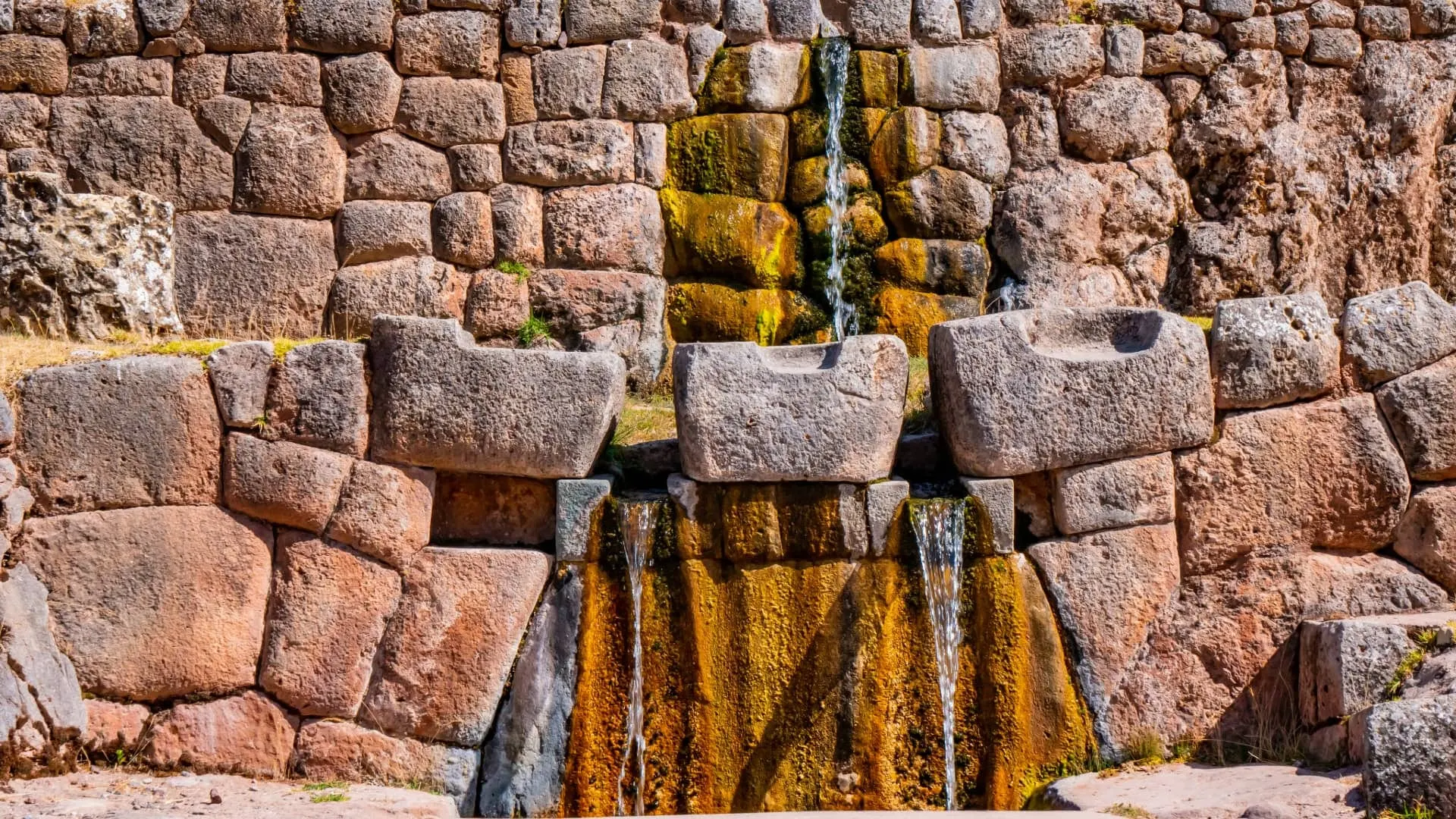
Tambomachay is an Inca complex devoted to water worship, known as “the Bath of the Inca,” about 7.5 km from Cusco on the road to Pisac and at an elevation of 3,805 m. Its terraced walls carry a spring through channels and fountains that keep flowing all year round. Right across from it is Puka Pukara, the “red fortress.” Both are visited with the Cusco Tourist Ticket.
What Is Tambomachay?
Tambomachay is an Inca archaeological site northeast of the city of Cusco, in a small ravine where a spring rises. The Incas channeled it with a highly precise hydraulic system: terraces of finely worked stone, trapezoidal niches and a network of channels that distributes the water into cascades and fountains.
The most widely accepted interpretations link it to water worship, one of the sacred elements of Andean religion, and to the leisure of the Inca nobility. Peru’s state news agency, Andina, describes it as a place where the Inca bathed and rested, also tied to the renewal of the earth. Hence its popular name, “the Bath of the Inca,” although it wasn’t a pool or a bath in today’s sense.
Was It Really the Bath of the Inca?
The idea has some basis, but it isn’t proven. Peru’s tourism ministry (Mincetur) says in its fact sheet that it was “apparently” the Inca’s favorite bathing place, and it compares its “Baño de la Ñusta” with the one at Ollantaytambo. PromPerú mentions ritual baths before religious or political events. The chronicler Bernabé Cobo, by contrast, says nothing about baths: he describes a house of Inca Yupanqui where the ruler stayed when he went hunting.
The Ministry of Culture’s Master Plan is more cautious. From its water-related structures, it concludes that the site was a shrine where rituals connected with water took place. Mincetur adds another reading, as a pillar of the valley’s defensive system. The safest position is the first one: a sacred place of water. A ritual bath is a reasonable possibility, not a documented fact.
The Spring and Water Worship
According to the Master Plan, fountains, springs (puquios) and small lakes (cochas) were places of worship, because water was tied to life, the fertility of the land and a good harvest. Tambomachay wasn’t an isolated project: the document describes a hydraulic system across the archaeological park with five subsystems, one of them Tambomachay, linked to terraces and connected to the Cusco valley. It also defines the site as a sacred place and a point of water control for the royal panacas, the noble lineages of Hanan Qosqo.
The site occupies both banks of the Tambomachay River, in the flat lower part of the ravine. Farther downstream, the same stream takes the name Cachimayo.
What Does Tambomachay Mean?
The name combines two Quechua words: tambo (tampu), the lodge or stopping place along the Inca road, and machay (mach’ay), which translates as “cave” or “shelter.” It’s usually explained as “resting place.” You’ll also see it spelled Tambomachai or Tampumachay.
Official sources don’t fully agree. The Mincetur fact sheet gives two readings: tampu as collective lodging and mach’ay as a resting place, or machay as a grotto or cave. The Master Plan alternates between Tambomachay and Tanpumachay, and it records a curious detail: on the left bank of the same river is a site called Mach’ay, a natural rock shelter 18 m wide and 7 m high, with a retaining wall and a stairway. Nothing proves the name comes from there, but it fits the meaning of “cave.” The shelter isn’t part of the tourist circuit.
History of Tambomachay and Puka Pukara
A Huaca on the Ceques of Antisuyu
The Incas arranged their sacred places, the huacas, along the ceques, imaginary lines that radiated from the Qorikancha. Cobo, writing in 1653, lists Tambomachay as the ninth huaca of the first ceque of Antisuyu and describes it this way: “it was a house of Inca Yupanqui, where he stayed when he went hunting” (our translation). He adds that it stood on a hill near the road to the Andes and that everything except children was sacrificed to it.
What If the Inca’s House Was Puka Pukara?
The site we call Tambomachay today may not be the one in the chronicle. The Master Plan notes that John Rowe and Susan Niles identify that ninth huaca with Puka Pukara, which stands next to the road that climbs to the Queser pass and continues toward Huchuy Qosqo. Building on that idea and on his fieldwork, the archaeologist Brian Bauer proposes that today’s Tambomachay would be the tenth huaca, Quinua Puquio, which Cobo describes as a spring near Tambomachay “made up of two springs” (our translation). These are hypotheses, not settled facts, but that detail is a reminder of the two spouts on the fountain you see today.
From High Pastureland to Peasant Community
After the conquest, the land changed use. A land grant from 1552 shows that the lands of Pucara, with their “castillo del Ynga” (Inca’s castle), belonged to don Felipe Topa Yupanqui Atauchi and bordered those of Tambomachay, owned by doña Juana Marcachimbo, both descendants of Túpac Yupanqui. A document from 1652 calls Puka Pukara “Pucaracay” and describes it as “unos paredones del tiempo del Ynga,” some big walls from the time of the Inca.
Because it lies above 3,700 m, the area was treated as puna, or high pastureland, with ranches and a hacienda devoted mainly to livestock. Tambomachay was already a hacienda in 1741 and remained one until the Agrarian Reform, when it became a cooperative. The Tambomachay peasant community organized in 1987.
Today both sites are among the 96 in the Saqsaywaman Archaeological Park, and the Master Plan places them in its strictly protected monumental zones. Their state of conservation is fair: damp and seepage weaken the structures at Tambomachay, and lichens are slowly damaging the stones at Puka Pukara.
What to See at Tambomachay
The Master Plan divides the site into three sectors: Fuentes (fountains), Andenes (terraces) and Pukara. The first is the one everyone comes to see.
The Ceremonial Fountains
This is the site’s most famous feature. Water runs down carved channels and comes out in a cascade that splits into two twin streams, which fall into a small pool. According to Andina, two aqueducts carved into the rock keep a steady flow of clean water all year, even in the dry season. Watching water run through a system more than five centuries old is the main reason to come.
The Fuentes sector is a series of four platforms. Across the two lower ones, about 1.20 m high, runs the channel that feeds the fountain, both lengthwise and crosswise. Notice how the stonework changes: the Master Plan singles out the craftsmanship of the fountain, which differs from the surrounding retaining walls of polygonal, cushion-faced masonry.
The Terraces and Niches
Behind the fountains rise several levels of terraced walls, with large trapezoidal niches, the classic shape of Inca architecture. The stones fit together tightly, without mortar, in the style of the empire’s most important buildings.
These are the two upper platforms, with tall walls and niches big enough for a person. The third wall is more than 3 m high and has two niches; the fourth has four. Several stairways connect the levels.
The Andenes and Pukara Sectors
The Andenes sector has two or three terraces and a second fountain of fine stonework, with a single spout, carved into the living rock. The Pukara sector, on the left bank of the river, is a tower-like structure built on a rock outcrop, supported by three terraces about 14 m long. Don’t confuse it with Puka Pukara, the site across the road.
The Setting
Tambomachay sits in an area of pastures and eucalyptus trees, with views of the hills around the Cusco valley. It’s the highest point on the circuit of Inca sites in the hills, and the road continues from here toward Pisac and the Sacred Valley. In the same ravine, the Master Plan records other minor sites, such as the terraces of Tuqowachana and Wallatawachana, and it lists the Qinuapuquio spring among its points of geological interest.
What to See, in Order
Tambomachay has no published official route, unlike Sacsayhuamán. Given the layout of the site, this order works well:
- The two lower platforms, with the channel that runs across them.
- The main fountain, with its two spouts.
- The tall walls with niches, up the stairway.
- The single-spout fountain in the Andenes sector.
- The tower in the Pukara sector, if access is open.
Puka Pukara, the Red Fortress
Across the road, a few minutes’ walk from Tambomachay, is Puka Pukara. Its Quechua name means “red fortress,” after the reddish tone its stones take on at sunset. It has rooms, inner plazas, terraces, stairways and the remains of channels, built on a small hill overlooking the road.
Why Is It Reddish?
Cosituc, the body that runs the Tourist Ticket, and Andina attribute the name to the color the stones take on at sunset. Mincetur gives a more specific reason: these are limestone blocks that have taken on the reddish color of iron-rich ground. The two explanations are compatible: the tone is in the stone, and low light brings it out.
Fortress, Tambo or Checkpoint?
Despite its name, it wasn’t a military fortress in the strict sense. It’s interpreted as a checkpoint and a tambo on the Inca road to the Sacred Valley: a place for keeping watch and for travelers to rest. According to Andina, when the Inca visited Tambomachay, he and his entourage stayed here.
Mincetur defines it as a site of administrative rather than military control, one that guarded Tambomachay and may have been a gateway to Cusco from Antisuyu. That fits the location: the Master Plan identifies stretches of the Qhapaq Ñan toward Antisuyu in this area, along with secondary roads toward Pisac, Corimarca and Taray. It also considers Puka Pukara a settlement of the royal ayllus of Hanan Qosqo. PromPerú, for its part, presents it as a military or lookout post. These roles don’t exclude one another, and the debate remains open.
What to See at Puka Pukara
- The wall: a very tall retaining wall that runs around almost the whole site, except on the west side.
- The platform: the Master Plan describes it as “a modo de usnu,” in other words, a ceremonial platform.
- The courtyard: five rectangular rooms around an open space, joined to a passage by a double-jamb doorway.
- The northern rooms: one keeps ten niches, six on the back wall and four on the front, and nearby is a ceremonial space with four more niches.
- The western fountains: two fountains linked to channels, a ceremonial hydraulic structure.
- The lookouts: two platforms to the southeast and, to the east, a hollow “a modo de chincana,” like a tunnel.
- The road: to the west is a pre-Hispanic stretch about 170 m long and 4 m wide.
- Time needed: 20 to 30 minutes.
- Admission: included in the same Tourist Ticket as Tambomachay.
Tip: visit Puka Pukara late in the afternoon, when the low light turns its walls red and you see why it got its name, but confirm the closing time first. In the morning, on the other hand, Tambomachay is less crowded.
How to Get to Tambomachay from Cusco
Tambomachay is about 7.5 km from the city, on the road from Cusco to Pisac, according to Andina. It’s the farthest site on the hillside circuit, so walking up from the center isn’t a good idea.
- By taxi: the most practical option. Mincetur estimates 15 to 20 minutes for the ride. Agree on the fare before you get in.
- By public transportation: the buses and shared vans (colectivos) that run from Cusco to Pisac pass along the road in front of the site; ask to be let off at Tambomachay. City bus lines are another matter: according to the Master Plan, one goes as far as Qenqo and another as far as Yuncaypata, so ask where it ends before you board.
- On a city tour: half-day city tours usually end here, after the Qorikancha, Sacsayhuamán, Qenqo and Puka Pukara.
Coming from Cusco, Puka Pukara is on the right side of the road and Tambomachay is on the left, along a gravel track about 800 m long, according to the Master Plan. The Tambomachay parking area is small and sits on a curve. The plan warns of the risk to visitors at the busiest times for tour buses, so be careful when you get out and when you cross.
The Walk Back to Cusco
The favorite plan for independent travelers is to take a taxi up to Tambomachay and walk back, downhill all the way, visiting the four sites on the circuit:
- Tambomachay: the starting point, and the highest.
- Puka Pukara: right opposite, across the road.
- Qenqo: down the road or along footpaths.
- Sacsayhuamán: about a 15-minute walk from Qenqo.
- Cusco: down through the San Cristóbal neighborhood to the Plaza de Armas.
With the visits, allow half a day. Set out early so you have time and good light, and don’t do the last stretch after dark.
The total descent is about 400 m. The two steepest drops are about 180 m between Puka Pukara and Qenqo and about 190 m between Sacsayhuamán and the Plaza de Armas. No official source publishes the length of the footpath. For reference, it’s about 7.5 km by road to the city and, in a straight line by the Master Plan coordinates, about 3 km from Puka Pukara to Qenqo and about 1.2 km from Qenqo to the walls of Sacsayhuamán. The Master Plan describes the circuit the other way around, from Sacsayhuamán to Tambomachay, by vehicle or on foot, and notes that an Inca ritual road already linked these places.
If you like walking, the same plan proposes a route along a stretch of the Qhapaq Ñan, from Puka Pukara to the Q’eser pass, at 4,042 m. It’s a proposal in the document, not a route you should assume is open: ask first at the regional office of the Ministry of Culture (Dirección Desconcentrada de Cultura).
Important: at 3,805 m (12,484 ft), Tambomachay is the highest site on the circuit, about 400 m above the Plaza de Armas. If it’s your first or second day in Cusco, visit by taxi or on a tour and save the walk down for when you’re acclimatized. More tips in our guide to altitude sickness in Cusco.
The Four Hillside Sites Compared
The 4 Inca sites next to Cusco: altitude of each
- Starting point
- Cusco (Plaza de Armas)3,399 m
- From nearest to farthest, along the Pisac road
- Sacsayhuamánthe walls, above the city3,591 m
- QenqoQenqo Grande3,603 m
- Puka Pukaraacross from Tambomachay3,786 m
- Tambomachayabout 7.5 km from the city3,805 m
| Site | Highlight | Elevation | Effort | Best time |
|---|---|---|---|---|
| Tambomachay | Fountains and channels with water all year | 3,805 m | Low, with some stairs | Morning |
| Puka Pukara | Reddish stone rooms and a view of the road | 3,786 m | Low | Late afternoon |
| Qenqo | Cave with a carved altar and a zigzag channel | 3,603 m | Low | Before 11:00 a.m. |
| Sacsayhuamán | Zigzag walls with giant blocks | 3,591 m | Moderate, because of its size | Morning or afternoon, in good light |
Why the Figures Vary by Source
Different numbers circulate for these sites, even in official sources. These are the figures this guide uses and the others you’ll come across:
| Figure | In this guide | Other official figures |
|---|---|---|
| Elevation of Tambomachay | 3,805 m (Master Plan) | 3,700 m (Mincetur and PromPerú) |
| Elevation of Puka Pukara | 3,786 m (Master Plan) | 3,764 m (Mincetur) |
| Cusco to Tambomachay | About 7.5 km (Andina) | 7.32 km and 8 km (Mincetur); 8 km (PromPerú) |
| Cusco to Puka Pukara | About 7 km (Mincetur) | 7.2 km (Mincetur, access table) |
| Between Tambomachay and Puka Pukara | A few minutes’ walk | 300 m (PromPerú); 1 km (Mincetur) |
We use the Master Plan elevations because they come from each site’s coordinates. By those same coordinates, Tambomachay and Puka Pukara are about 700 m apart in a straight line.
Admission and Hours
Tambomachay and Puka Pukara don’t sell individual tickets: both are visited with the Cusco Tourist Ticket. Either the 10-day full ticket or the Circuit I partial ticket, which also covers Sacsayhuamán and Qenqo, will do. If you don’t have your ticket yet, you can buy it at the ticket booth of any of the four sites, in person and with your ID. These are the Cosituc fares:
| Ticket | What it covers | Valid for | Foreign visitors | Peruvians and residents |
|---|---|---|---|---|
| Circuit I partial | Sacsayhuamán, Qenqo, Puka Pukara and Tambomachay | Foreign visitors: 5 days. Nationals: 1 day | S/ 70 | S/ 40 |
| Full ticket | All three circuits of the ticket | 10 days | S/ 130 | S/ 70 |
| Full student ticket | All three circuits of the ticket | 10 days | S/ 70 | S/ 40 |
Fares checked on October 31, 2026. Confirm them on the official channel before you buy.
Hours at Tambomachay and Puka Pukara
We haven’t found a single official schedule published by Cosituc or the regional office of the Ministry of Culture, and the available figures don’t match. In 2018, Andina gave Monday to Sunday, 7:00 a.m. to 6:00 p.m., for the sites on this circuit. The Mincetur fact sheet for Tambomachay says 8:00 a.m. to 4:00 p.m., and the one for Puka Pukara says 6:30 a.m. to 4:00 p.m. The Master Plan, for its part, records tour groups at Tambomachay until 5:30 p.m.
Important: to be safe, visit both sites between 8:00 a.m. and 4:00 p.m., the window on which all these sources agree, and confirm the hours when you buy your ticket.
How Much Time You Need
Allow 30 to 45 minutes for Tambomachay and 20 to 30 for Puka Pukara. With the walk between them, that comes to about an hour and a half. If you’re doing all four sites on the circuit, set aside half a day.
When to Go, Weather and What to Bring
The Master Plan places the busiest times at Tambomachay at 11:00 a.m. to 1:00 p.m. and 3:00 to 5:30 p.m. For a quieter visit, go first thing in the morning or between those two windows. Puka Pukara gets fewer people: according to 2018 Cosituc figures cited by Mincetur, it had about 323,000 visits, compared with about 468,000 at Tambomachay.
Tambomachay is more exposed than central Cusco: it’s windier and colder, especially first thing in the morning and at sunset, and the midday sun burns. In the rainy season, from December to March, showers tend to arrive in the afternoon and the path down gets muddy. Read the details in Cusco weather and pack your daypack with our Cusco packing list:
- A warm layer and a windbreaker.
- A cap, sunglasses and sunscreen.
- Water and a snack: services are limited, so don’t count on them.
- Shoes with good soles for the footpaths on the way down.
- Your Tourist Ticket and your ID.
What Services Are There?
The Mincetur fact sheets list handicraft sales, restrooms and guides at both sites, and food and drink kiosks at Puka Pukara. The Master Plan warns that the restrooms at Tambomachay are inadequate and were in poor condition, and that the park has no site museum or interpretation center. Read up on the essentials beforehand or hire an official guide. And stay out of closed areas: damp is already weakening these structures.
Bottom Line: Tambomachay for Every Traveler
- Traveling independently: a taxi to Tambomachay, a visit to Puka Pukara and a walk down past Qenqo and Sacsayhuamán.
- Short on time or just arrived: an afternoon city tour, with transportation, that ends here.
- Into Inca engineering: combine it with Tipón, in the South Valley, another great site of channels and fountains.
- Hoping to avoid groups: arrive first thing in the morning and leave Puka Pukara for the end of your visit.
- Continuing to the valley: it’s on the way to Pisac and the Sacred Valley.
For the rest of the city, with times and admission, read things to do in Cusco and, to fit it into your trip, our 3-, 5- and 7-day Cusco itinerary.
Frequently asked questions
What is Tambomachay?
An Inca archaeological site with terraces, channels and fountains that still carry water all year. It’s linked to water worship and to the leisure of the Inca nobility.
What does Tambomachay mean?
It joins tambo, the stopping place on the Inca road, and machay, “cave” or “shelter” in Quechua. It’s usually translated as “resting place.”
Why is it called the Bath of the Inca?
Because of its ceremonial fountains, where the water falls in two twin streams. Andina and PromPerú mention rest and ritual baths, but the chronicler Cobo describes a hunting house of Inca Yupanqui, and the Master Plan a water shrine.
What is Puka Pukara?
An Inca site across from Tambomachay whose name means “red fortress.” It’s interpreted as a tambo and a checkpoint on the road; Mincetur considers it more administrative than military.
How do I get to Tambomachay from Cusco?
By taxi, on the buses and colectivos that go to Pisac or on a city tour. Many travelers take a taxi up and walk back downhill past Puka Pukara, Qenqo and Sacsayhuamán.
How much does it cost to visit Tambomachay?
Individual tickets aren’t sold. The Circuit I partial Tourist Ticket costs S/ 70 for foreign visitors and S/ 40 for Peruvians and residents; the full ticket costs S/ 130 and S/ 70, according to Cosituc.
What is the elevation of Tambomachay?
About 3,805 m (12,484 ft) according to the Ministry of Culture’s Master Plan, the highest point among the Inca sites in the hills of Cusco. Some sources round it to 3,700 m. If you’ve just arrived, visit by taxi or on a tour.
What are the opening hours of Tambomachay?
No single official schedule is published. Andina gave 7:00 a.m. to 6:00 p.m. in 2018, and the Mincetur fact sheet says 8:00 a.m. to 4:00 p.m. Arrive before 4:00 p.m. and confirm the hours when you buy your ticket.
How much time do you need for Tambomachay and Puka Pukara?
30 to 45 minutes for Tambomachay and 20 to 30 for Puka Pukara. With the walk between them, it comes to about an hour and a half.
How far is Tambomachay from Puka Pukara?
A few minutes’ walk. PromPerú says 300 m and Mincetur says 1 km; the Master Plan coordinates put them about 700 m apart in a straight line.
Can you walk back from Tambomachay to Cusco?
Yes, going down past Puka Pukara, Qenqo and Sacsayhuamán, with a descent of about 400 m. Allow half a day with the visits, set out early and save it for when you’re acclimatized.
Why is Puka Pukara reddish?
Mincetur attributes it to limestone that took on the color of iron-rich ground. Cosituc and Andina highlight the tone the stones take on at sunset.
Official sources
- Cosituc: Tambomachay, destination fact sheet cosituccusco.pe
- Cosituc: Puka Pukara, destination fact sheet cosituccusco.pe
- Cosituc: Cusco Tourist Ticket fares cosituccusco.pe
- Mincetur: Tambomachay archaeological site, tourism resource inventory fact sheet (in Spanish) consultasenlinea.mincetur.gob.pe
- Mincetur: Pukapukara archaeological site, tourism resource inventory fact sheet (in Spanish) consultasenlinea.mincetur.gob.pe

How we put this guide together
Written by Paul Pumalloclla · 17 years in tourism
- Official sources Prices, opening hours and rules checked against Peru’s Ministry of Culture, SERNANP, PromPerú and the train and bus operators.
- Sources cited Every guide links to the sources we used at the end.
- Always up to date When a rule changes, we update the guide and its date.
We’re not a travel agency: we don’t sell tours or take bookings. If a link belongs to a commercial partner, we label it next to the link, and that never changes the facts or the recommendations.
Guide history
- Published
- Last reviewed
Spotted something out of date?
Let us know and we’ll check it against the official source.
Report a change