Key facts
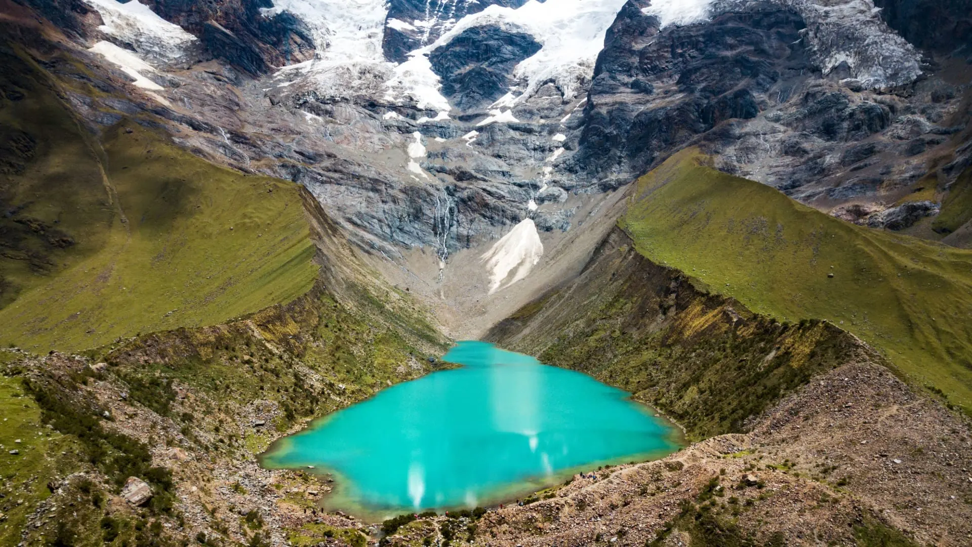
- Humantay Lake is a turquoise glacial lake at the foot of snowcapped Humantay (5,473 m), in the Salkantay massif.
- It’s in Mollepata District (Anta Province), about 3 hours by road from Cusco to Soraypampa.
- It sits at an elevation of about 4,200 m according to Mincetur; the trail starts in Soraypampa, at about 3,800 m.
- The hike is about 6 km round trip, with a steep 1 h 30 min climb; horses are available for an extra fee.
- The entrance fee is paid in cash and isn’t covered by the Cusco Tourist Ticket: Mincetur recorded S/ 10 for foreigners and S/ 5 for Peruvians in 2022.
- Rain can close access and Inaigem warns of avalanches: confirm the day before and don’t linger by the lake’s outlet.
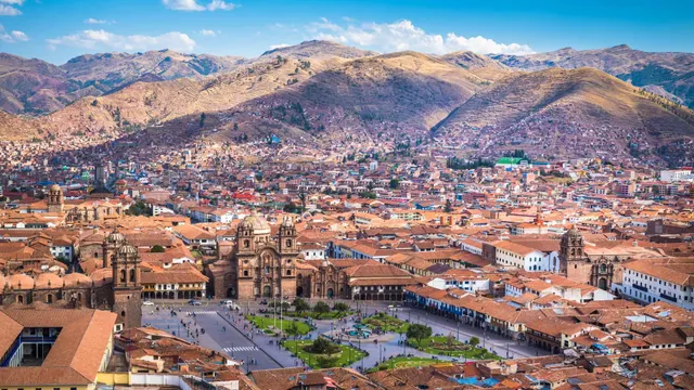
Humantay Lake is a turquoise glacial lake at an elevation of about 4,200 m, at the foot of snowcapped Humantay, in the Salkantay massif (Vilcabamba mountain range). It’s in Mollepata District, about 3 hours from Cusco by road, and you reach it on a steep hike of around 1 h 30 min from Soraypampa. After Rainbow Mountain, it’s the most popular high-mountain day trip from Cusco, and a little lower.
Humantay Lake at a glance
| Fact | Humantay Lake |
|---|---|
| Other names | Laguna Humantay, Laguna de Humantay, Lake Humantay, Humantay Lagoon |
| Location | Mollepata District, Anta Province, Cusco Region |
| Elevation | About 4,200 m |
| Trailhead | Soraypampa, at about 3,800 m |
| Distance from Cusco | About 3 hours by road to Soraypampa |
| Hike | About 6 km round trip; 1 h 30 min up |
| Entrance fee | Paid on site, in cash; not covered by the Cusco Tourist Ticket |
| Opening hours | 5:30 a.m. to 5:00 p.m., according to Mincetur’s record |
| Managed by | Mollepata District Municipality |
| Best season | April to November |
Where is Humantay Lake?
Humantay Lake is in Mollepata District, in Anta Province, west of Cusco. It fills a glacial basin right below snowcapped Humantay, the neighbor of Salkantay, the area’s great glaciated peak at over 6,000 m. It’s the same valley where the Salkantay trek begins: from Soraypampa, one trail climbs to the lake and another continues toward the Salkantay Pass and, days later, on to Machu Picchu.
To get there you take the highway from Cusco to Abancay, which descends through the Limatambo Valley, and then climb up to Mollepata, a farming town at almost 3,000 m. From there, an unpaved mountain road leads to Soraypampa, where the road ends. In Soraypampa there are campsites, simple lodges and small shops that serve the day trips and the treks.
Snowcapped Humantay and Salkantay
The peak reflected in the lake stands 5,473 m tall, according to the underwater study of the lake published by Peru’s Ministry of Culture. Mincetur’s record calls it Apu Humantay and translates its name as “head of the gods”: for the local communities it’s an apu, a guardian mountain. At the other end of the valley rises Apu Salkantay, at 6,271 m according to PromPerú. A legend retold by PromPerú says the lake was born from Salkantay’s tears, when he returned to Cusco so his people wouldn’t go without water.
The two peaks share a valley, a trailhead and also their management: the regional government treats them as a single tourist route, Humantay–Salkantay–Machu Picchu. If you want to keep walking from the lake all the way to Machu Picchu, you’ll find the stages, elevations and difficulty in our Salkantay guide.
Humantay Lake elevation
Humantay Lake’s elevation is about 4,200 m, roughly 800 m higher than the city of Cusco (3,399 m). The trail starts in Soraypampa, at about 3,800 m according to El Comercio, so on the hike you gain about 400 m of elevation over about 3 km. That’s lower than Rainbow Mountain, at about 5,036 m, but the slope is steeper.
| Place | Approximate elevation |
|---|---|
| Cusco | 3,399 m |
| Mollepata | Almost 3,000 m |
| Soraypampa, trailhead | About 3,800 m |
| Humantay Lake | About 4,200 m |
| Salkantay Pass, on the trek | 4,630 m |
| Snowcapped Humantay | 5,473 m |
4,200 or 4,270 m? What official sources say
The 4,200 m figure comes from Mincetur’s inventory of tourist resources, in the lake’s record dated October 2022. A team of underwater archaeologists who studied the lake in 2016 and 2017, in research published by the Ministry of Culture, measured it by GPS at about 4,270 m. The difference is small and changes nothing for your acclimatization.
What is a mistake is the 5,473 m figure given as the lake’s elevation in some Andina articles and on PromPerú’s page: that’s the height of the peak, not of the water. The trailhead has a similar issue: El Comercio puts Soraypampa at about 3,800 m and Andina at 3,900 m. Depending on which figures you use, the hike up gains between 300 and 470 m.
Important: 4,200 m is a lot of altitude for the first or second day of your trip. Do Humantay on your third or fourth day at the earliest, and only without symptoms of soroche (altitude sickness). We explain why in our guide to altitude sickness in Cusco.
How to get to Humantay Lake from Cusco
Day trip
This is the most common way to go. Operators pick you up at your hotel around 4:30 a.m., stop for breakfast in Mollepata and reach Soraypampa by mid-morning. After the hike, you head down for lunch and return to Cusco in the afternoon. According to El Comercio, the full day lasts about 14 hours. Trips usually include transportation, breakfast, lunch and a guide; the entrance fee and the horse are almost always extra.
On your own
You can take public transportation to Mollepata along the Abancay highway, but there’s no regular service from there to Soraypampa: you’ll need to hire a car in town, and to arrive at a good time you’d have to leave Cusco before dawn. A more comfortable alternative is a private car with a driver. If you’d like things calmer, you can sleep in Soraypampa the night before and hike up first thing in the morning, before the groups arrive.
Distances and travel times according to Mincetur
Mincetur’s official record splits the trip into three legs. Add stops and the traffic leaving Cusco: PromPerú estimates about 3 h 30 min from Cusco to Soraypampa by bus or car.
| Leg | Distance | Time | How |
|---|---|---|---|
| Cusco – Mollepata main square | 97 km | 2 h | Paved highway |
| Mollepata – Soraypampa | 25 km | 1 h 10 min | Mountain road |
| Soraypampa – lake | About 3 km, according to El Comercio | 1 h (Mincetur) to 1 h 30 min (PromPerú) | On foot, or partly on horseback |
In 2022, the regional government, through Plan COPESCO, signed an agreement with the Anta and Mollepata municipalities to improve and pave the Mollepata–Soraypampa road, build a footpath to the lake and an interpretation center at the Mollepata bus terminal, with more than 33 million soles budgeted for 2023–2025. We haven’t found an official source saying how much of it has been built, so don’t count on those works yet.
The access routes: Balconpata and Llaqtallaqtalloq
The main access runs through the Balconpata sector, the one hit hardest by landslides. In 2026, access to the lake was closed on February 6 because of heavy rain and a geological fault in that sector, and it reopened on March 6 along an alternative trail, Llaqtallaqtalloq, which the Mollepata Municipality rehabilitated. If you go in the rainy season, you may well hike up that way rather than on the usual route.
As part of the Salkantay trek
The first day of the Salkantay trek climbs to the lake for acclimatization. If you’re already doing the trek, don’t book Humantay separately. Compare routes in our Machu Picchu treks compared guide.
The Humantay Lake hike
The trail leaves Soraypampa and zigzags up a slope of grass and rock, with no technical sections but a steady incline. According to El Comercio, it’s about 6 km round trip and 3 to 4 hours in total, including breaks. The climb takes around 1 h 30 min, the time PromPerú gives; the descent, on the same trail, less than an hour.
- First stretch: a gentle grade along the valley floor, good for warming up.
- Middle stretch: the steepest part, with tight switchbacks. This is where almost everyone stops often.
- Arrival: the trail levels off just before you look out over the lake.
The communities offer horses for a good part of the climb, paid separately in cash. The last stretch, which is very short, is on foot. Keep in mind that a horse saves you effort, not altitude: soroche can still hit you, so you still need to acclimatize. Agree on the price and how far the horse goes before you get on.
Is the Humantay Lake hike hard?
It’s moderately difficult: short, but steep and at altitude. A healthy person who walks regularly can finish it without trouble if they’re acclimatized and go slowly. The hardest part is the middle stretch, because of the slope and the thinner air. If you have knee problems, trekking poles help a lot on the way down.
Tip: on the climb to Humantay, it’s better to walk slowly and steadily than to go fast and stop every few yards.
What to see at Humantay Lake
- The lake: water that shifts from green to turquoise to sky blue depending on the light, surrounded by moraines.
- Snowcapped Humantay: its tongue of ice reaches almost down to the water, and it’s what feeds the lake.
- The moraine viewpoint: a path climbs the side ridge to a higher point, with the best view of the whole lake.
- The apachetas: stone cairns built by visitors and community members as offerings to the apus, the sacred mountains.
- The Soraypampa valley: with Salkantay in the background on clear days.
The lake is a sacred place for the local communities. Don’t swim in it, don’t throw anything into the water and follow the community’s instructions.
The lake by the numbers
The official sources don’t fully agree, because they measured in different years and with different methods. These are their figures:
| Fact | Value | Source |
|---|---|---|
| Elevation | 4,200 m | Mincetur (2022 record) |
| Elevation measured by GPS | About 4,270 m | Ministry of Culture (2016–2017 study) |
| Length and width | About 618 m by 164 m | Mincetur |
| Surface area | 58,273 m²; about 6 hectares | Mincetur; Ministry of Culture |
| Perimeter | 1,427 m | Mincetur |
| Depth | 17 m; up to 20 m in the southern part | Mincetur; Ministry of Culture |
| Volume of water | About 500,000 m³ | Inaigem (2026) |
| Average water temperature | 8 °C | Ministry of Culture |
According to Mincetur, the turquoise color comes from the clarity of the water, green microalgae and the reflection of the sky and sun. The divers in the Ministry of Culture study found that the maximum depth went from 18 to 20 m between July 2016 and 2017, and they noted obvious glacier retreat in just one year. On the lake bed and the shore they found no remains of pre-Hispanic offerings: today’s apachetas are a living custom.
Plants and wildlife
Mincetur’s record mentions queñua trees, tayanka shrubs and ichu grass around the lake. Among wild animals it lists viscachas, taruca (the Andean deer), Andean foxes, huallatas, Andean geese, waterbirds and the Andean condor; horses, cows and sheep also graze in the valley. Walk quietly and outside peak hours if you want to see some of them. If you’re interested in camelids, our guide to llamas and alpacas in Cusco tells you where to see them.
Humantay Lake entrance fee
The Humantay entrance fee is paid on site, in cash and in soles, at a checkpoint on the trail. It isn’t included in the Cusco Tourist Ticket. The latest rate published by a public body that we’ve found is in Mincetur’s record dated October 11, 2022: S/ 10 for foreigners, S/ 5 for Peruvians and free for local residents with a national ID. The amount may have changed since then, so confirm it before you go, and bring your ID and small bills for the entrance fee, the horse and other services. For the total cost of your trip, see our Cusco trip budget.
The same record lists visiting hours of 5:30 a.m. to 5:00 p.m. Day trips reach Soraypampa by mid-morning, so if you sleep there you can hike up earlier and with fewer people.
Who manages the lake and what rules apply
The Mollepata District Municipality directly manages the lake. On December 26, 2025, the Anta Provincial Municipality declared it a site of Provincial Public Tourist Interest through Municipal Ordinance No. 023-2025-CM-MPA. The ordinance calls for prioritizing infrastructure, safety, signage and conservation projects on the route, and aims for a Sustainable Use Plan and a carrying-capacity control system, in other words, a cap on visitors. It also orders rules for the transportation companies, guides and operators working on the route.
At the regional level, the Management Committee for the Humantay–Salkantay–Machu Picchu tourist route was formed in August 2025, chaired by Gercetur, the regional tourism office. Its members include the municipalities of Anta, La Convención, Mollepata, Santa Teresa and Machu Picchu, the Ministry of Culture’s Cusco office and Sernanp, the protected areas agency, and one of its agreements was to draft rules to control tourist entry. We haven’t found any published rules or a daily cap in force. For now, Gercetur estimates 800 to 1,200 visits a day.
Weather, best season and safety
Mincetur’s record sums up the climate in two seasons: from December to April, mild and rainy; from May to November, cold, with lots of sunshine during the day. PromPerú gives a range of 1 °C to 20 °C. Early mornings in Soraypampa are very cold, often below zero in the dry season. In the sun, by mid-morning the day turns pleasant, but a cold wind usually blows off the glacier by the lake.
- April to November: the best time to go, with more clear days and a dry trail.
- May to September: the driest months and the busiest.
- December to March: frequent rain, a slippery trail and clouds that hide the snowcapped peak.
Rain can also cut off access. In March 2025, for example, a landslide in the Balconpata sector, the main access route, dammed the Blanco River and tourist entry was suspended until further notice. On top of that, the retreat of the glacier makes the area more unstable: in July 2026, Inaigem, the public institute that studies Peru’s glaciers, recommended assessing the risk of avalanches from snowcapped Humantay into the lake, which it estimated at about 500,000 m³ of water and about 20 m deep, and it identified Soraypampa as the most exposed area.
Avalanches in 2026: what we know
Since July 2026, visitors have filmed several snow avalanches falling from the peak toward the lake, with no one hurt. In September, Inaigem warned that the greatest danger is people’s exposure: according to its specialists, every visitor reaches the most critical zone, the area around the outlet where the lake overflows, and any event that destabilizes the water would hit exactly that spot. The institute recommended updating emergency plans, reviewing the access routes and, in some cases, limiting the number of people. In July it had already called for an early warning system, which the lake doesn’t have.
Important: confirm the day before that access is open, especially between December and April. At the lake, don’t linger by the outlet or on the shore below the glacier, and follow the instructions of your guide and the community members. Month-by-month weather details are in our guide to Cusco weather.
Humantay Lake or Rainbow Mountain
| Humantay Lake | Rainbow Mountain | |
|---|---|---|
| Landscape | A turquoise lake at the foot of a glacier | Stripes of colored minerals and Ausangate |
| Maximum elevation | About 4,200 m | About 5,036 m |
| Hike | About 1 h 30 min up, very steep | 1 h 30 min to 2 h up, gentler but higher |
| Drive from Cusco | About 3 h, to the west | About 3 h, to the southeast |
| Best for | Those who prefer less altitude | Hikers who are already well acclimatized |
If you only have one day for the high mountains and it’s your first trip at altitude, Humantay is usually the more manageable choice. If you want rainbow mountains without as much effort, there’s a third option: Palcoyo.
All three trips follow the same kind of day: a predawn pickup, 3 to 4 hours on the road and an entrance fee paid in cash. What changes is where the effort lies. At Humantay it’s the slope, because you climb several hundred meters on foot from Soraypampa. At Rainbow Mountain it’s the altitude, above 5,000 m. At Palcoyo you walk little, because the vehicle drops you near the top. And if you’re traveling between December and March, remember that access to Humantay has been closed several times because of landslides.
What to bring
- Layers: a thermal base layer, a fleece, a down jacket and a rain jacket.
- A warm hat, gloves and a neck gaiter for the early morning.
- Hiking shoes with good grip and, if you use them, trekking poles.
- Sunscreen, sunglasses and a cap.
- Water and a snack or two.
- Cash in soles, in small bills.
- Your ID or passport: the fee differs for foreigners, Peruvians and locals.
- A bag to carry your trash back down.
The full list by season is in our Cusco packing list.
Summary: what to do in your situation
- You want a high-mountain day trip without going above 4,500 m: Humantay Lake, from your third day in Cusco onward.
- You’re doing the Salkantay trek: don’t book it separately; it’s on the first day.
- You want to avoid the groups: sleep in Soraypampa and hike up at sunrise; Mincetur’s record lists opening hours from 5:30 a.m.
- You’re traveling in the rainy season: confirm the day before that access is open and which route you’ll take up.
- You’re already at the lake: take your photos away from the outlet and from the shore below the glacier.
- Rainbow mountains appeal to you more: choose between Rainbow Mountain and Palcoyo.
- You’re putting your trip together: place Humantay toward the end in our Cusco itinerary.
Frequently asked questions
Where is Humantay Lake?
In Mollepata District, Anta Province, in the Cusco Region of Peru. It lies at the foot of snowcapped Humantay, next to Salkantay, about 3 hours by road west of the city of Cusco.
What is the elevation of Humantay Lake?
About 4,200 m above sea level according to Mincetur’s tourism inventory; a study published by the Ministry of Culture measured it by GPS at about 4,270 m. It’s roughly 800 m higher than Cusco, so it’s best to go on your third or fourth day of the trip or later.
How do you get to Humantay Lake?
Along the Cusco–Abancay highway to Mollepata (97 km according to Mincetur), then about 25 km more to Soraypampa. From there you hike up in around 1 h 30 min. Most travelers go on a day trip.
Is the Humantay Lake hike difficult?
It’s moderate: the route is short, but steep and at altitude. If you’re acclimatized and go slowly, any healthy person who walks regularly can do it without trouble.
How long is the hike to Humantay Lake?
PromPerú estimates around 1 h 30 min up from Soraypampa, and Mincetur’s record says 1 h. With the descent and time at the shore, El Comercio puts the total at 3 to 4 hours.
How much is the Humantay Lake entrance fee?
It’s paid on site, in cash and in soles, and isn’t part of the Cusco Tourist Ticket. Mincetur’s October 2022 record listed S/ 10 for foreigners, S/ 5 for Peruvians and free entry for local residents with ID; confirm the current amount before you go.
What are Humantay Lake’s opening hours?
Mincetur’s record lists 5:30 a.m. to 5:00 p.m. Day trips arrive by mid-morning; if you sleep in Soraypampa you can hike up earlier and with fewer people.
When is the best time to visit Humantay Lake?
From April to November, when there are more clear days. From December to March it rains often, the trail gets slippery and access has been suspended several times because of landslides, as in February 2026.
How deep is Humantay Lake?
Mincetur’s record gives 17 m; the study published by the Ministry of Culture measured up to 20 m in the southern part in 2017. Inaigem estimates its volume at about 500,000 m³ of water.
Is Humantay Lake dangerous because of avalanches?
Several avalanches fell from the peak in 2026, with no one hurt. Inaigem identifies the area around the lake’s outlet as the most critical zone: don’t linger there or on the shore below the glacier, and follow local instructions.
Can you swim in Humantay Lake?
It’s not a good idea: the water is ice-cold, it comes from the glacier and the lake is a sacred place for the communities. Enjoy it from the shore and the viewpoint.
Humantay Lake or Rainbow Mountain?
Humantay is lower, at about 4,200 m, and its draw is the lake at the foot of the glacier. Rainbow Mountain reaches about 5,036 m and calls for better acclimatization.
Official sources
- Mincetur: Inventory of tourist resources, Laguna de Humantay record (elevation, access, fees and hours; October 2022) consultasenlinea.mincetur.gob.pe

How we put this guide together
Written by Paul Pumalloclla · 17 years in tourism
- Official sources Prices, opening hours and rules checked against Peru’s Ministry of Culture, SERNANP, PromPerú and the train and bus operators.
- Sources cited Every guide links to the sources we used at the end.
- Always up to date When a rule changes, we update the guide and its date.
We’re not a travel agency: we don’t sell tours or take bookings. If a link belongs to a commercial partner, we label it next to the link, and that never changes the facts or the recommendations.
Guide history
- Published
- Last reviewed
Spotted something out of date?
Let us know and we’ll check it against the official source.
Report a change